Huapinol night lights from space
Night Light of Huapinol (Tabasco) from space (Mexico) Src. Average luminocity for 10x10km area is 51.9134% and for 50x50km: 32.4666%.
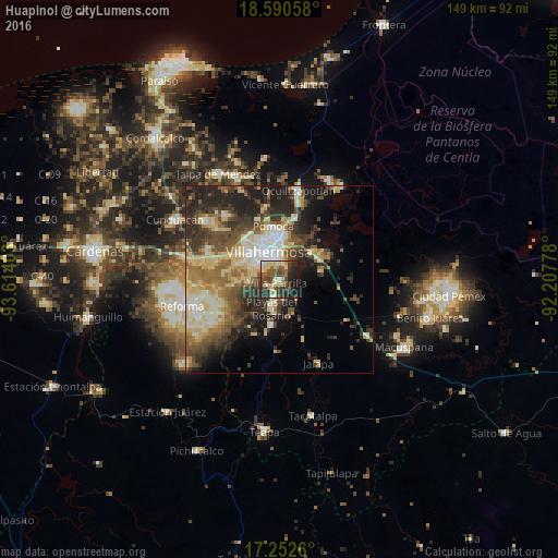
Analysis of Huapinol night lights 2016
Square area 10x10 km:
 2.6%
2.6%90-99
8.01%80-89
16.23%70-79
3.46%60-69
3.46%50-59
12.77%40-49
14.07%30-39
14.72%20-29
15.15%10-19
9.52%0-9
0%Square area 50x50 km:
3.33%90-99
5.76%80-89
7.36%70-79
2.7%60-69
4.48%50-59
5.33%40-49
6.17%30-39
7.08%20-29
9.16%10-19
10.36%0-9
38.28%Clear (daylight) street map image can be seen on geolist.org.
Map coordinates:
18° 35' 26.1" North, 93° 36' 50.5" West
17° 55' 22.3" North, 92° 54' 39.2" West
17° 15' 9.4" North, 92° 12' 28" West
Some cities around Huapinol sort by population:
• Villahermosa
7.4 km =4.6 mi,  343°
343°
• Playas del Rosario
8.1 km =5 mi,  196°
196°
• Parrilla II
5 km =3.1 mi,  193°
193°
• Parilla
1 km =0.6 mi,  214°
214°
• Bosque de Saloya
11.5 km =7.1 mi,  334°
334°
• La Selva
12.5 km =7.8 mi, 333°
• Río Viejo Primera Sección
7.6 km =4.7 mi,  283°
283°
• La Lima
2.8 km =1.7 mi,  240°
240°
6690612 (p: 5,768)
Sources (retrieved 2019-11-25):
» Earth at Night: Flat Maps 2012, 2016