Jerécuaro night lights from space
Night Light of Jerécuaro (Guanajuato) from space (Mexico) Src. Average luminocity for 10x10km area is 10.3175% and for 50x50km: 6.7956%.
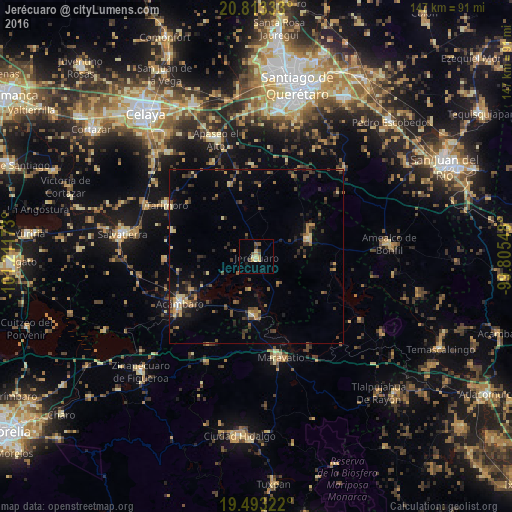
Analysis of Jerécuaro night lights 2016
Square area 10x10 km:
 0%
0%90-99
1.19%80-89
1.59%70-79
3.57%60-69
0%50-59
2.18%40-49
2.18%30-39
0.79%20-29
0.6%10-19
1.59%0-9
86.31%Square area 50x50 km:
0.07%90-99
0.27%80-89
1.01%70-79
1.01%60-69
0.99%50-59
0.77%40-49
1.72%30-39
1.76%20-29
1.97%10-19
2.97%0-9
87.46%Clear (daylight) street map image can be seen on geolist.org.
Map coordinates:
20° 48' 48" North, 101° 12' 42.2" West
20° 9' 16.8" North, 100° 30' 31" West
19° 29' 35.6" North, 99° 48' 19.7" West
Some cities around Jerécuaro sort by population:
• Acámbaro
26.2 km =16.3 mi,  238°
238°
• Salvatierra
39.3 km =24.4 mi,  279°
279°
• Maravatío de Ocampo
30.1 km =18.7 mi,  167°
167°
• Apaseo el Alto
35.7 km =22.2 mi,  340°
340°
• Tarimoro
29.4 km =18.3 mi,  299°
299°
• Urireo
35.4 km =22 mi, 280°
• Amealco
38.1 km =23.7 mi,  84°
84°
• Tarandacuao
17.1 km =10.6 mi,  183°
183°
4004026 (p: 7,748)
Sources (retrieved 2019-11-25):
» Earth at Night: Flat Maps 2012, 2016