El Llano night lights from space
Night Light of El Llano (Hidalgo) from space (Mexico) Src. Average luminocity for 10x10km area is 66.7262% and for 50x50km: 27.7957%.
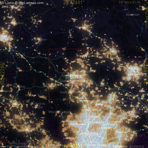
Analysis of El Llano night lights 2016
Square area 10x10 km:
 8.13%
8.13%90-99
10.71%80-89
12.7%70-79
13.69%60-69
21.63%50-59
7.34%40-49
10.91%30-39
8.73%20-29
5.75%10-19
0.4%0-9
0%Square area 50x50 km:
1.03%90-99
1.66%80-89
3.93%70-79
5.25%60-69
8.1%50-59
4.26%40-49
6.19%30-39
6.57%20-29
9.05%10-19
15.42%0-9
38.54%Clear (daylight) street map image can be seen on geolist.org.
Map coordinates:
20° 43' 27.9" North, 100° 1' 22.4" West
20° 3' 55.3" North, 99° 19' 11.1" West
19° 24' 12.8" North, 98° 36' 59.9" West
Some cities around El Llano sort by population:
• Tula de Allende
3 km =1.9 mi,  238°
238°
• Tlaxcoapan
10.8 km =6.7 mi,  74°
74°
• San Marcos
4.2 km =2.6 mi,  202°
202°
• Cardonal
9.4 km =5.8 mi,  95°
95°
• Tlahuelilpan
11.7 km =7.3 mi,  51°
51°
• San Miguel Vindho
7.9 km =4.9 mi,  178°
178°
• Doxey
8.5 km =5.3 mi, 69°
• Atitalaquia
10.3 km =6.4 mi,  93°
93°
3528788 (p: 14,559)
Sources (retrieved 2019-11-25):
» Earth at Night: Flat Maps 2012, 2016