Hueytamalco night lights from space
Night Light of Hueytamalco (Puebla) from space (Mexico) Src. Average luminocity for 10x10km area is 4.474% and for 50x50km: 7.6252%.
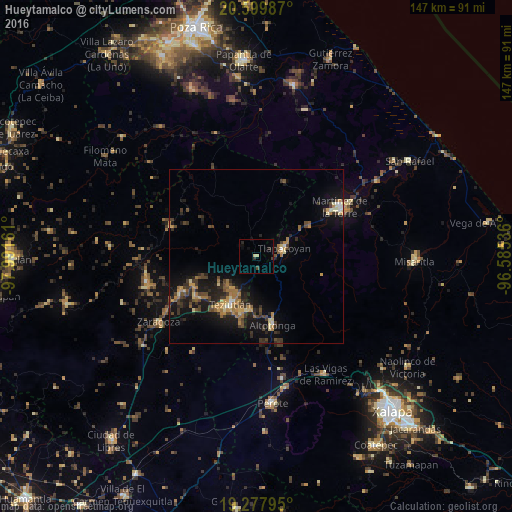
Analysis of Hueytamalco night lights 2016
Square area 10x10 km:
 0%
0%90-99
0%80-89
1.73%70-79
0%60-69
0%50-59
0%40-49
1.3%30-39
0.65%20-29
1.95%10-19
1.73%0-9
92.64%Square area 50x50 km:
0.17%90-99
0.31%80-89
1.07%70-79
1.16%60-69
1.59%50-59
0.74%40-49
1.94%30-39
1.84%20-29
2.35%10-19
6.91%0-9
81.92%Clear (daylight) street map image can be seen on geolist.org.
Map coordinates:
20° 35' 59.5" North, 97° 59' 29.8" West
19° 56' 25" North, 97° 17' 18.5" West
19° 16' 40.6" North, 96° 35' 7.3" West
Some cities around Hueytamalco sort by population:
• Teziutlan
15.6 km =9.7 mi,  208°
208°
• Tlapacoyan
8.4 km =5.2 mi,  72°
72°
• Altotonga
19.9 km =12.4 mi,  166°
166°
• Jalacingo
15.4 km =9.6 mi,  187°
187°
• Chinautla
17 km =10.6 mi,  218°
218°
• San Juan Xiutetelco
16.6 km =10.3 mi, 193°
• Hueyapán
17.6 km =10.9 mi,  248°
248°
• Atoluca
11.7 km =7.3 mi, 215°
3526927 (p: 5,335)
Sources (retrieved 2019-11-25):
» Earth at Night: Flat Maps 2012, 2016