Jalacingo night lights from space
Night Light of Jalacingo (Veracruz) from space (Mexico) Src. Average luminocity for 10x10km area is 32.5785% and for 50x50km: 8.2092%.
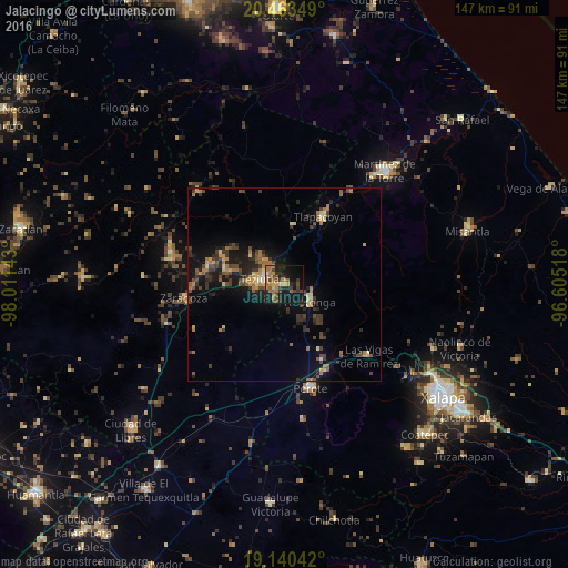
Analysis of Jalacingo night lights 2016
Square area 10x10 km:
 0%
0%90-99
0.83%80-89
2.89%70-79
5.37%60-69
14.26%50-59
2.69%40-49
9.5%30-39
6.4%20-29
13.84%10-19
31.82%0-9
12.4%Square area 50x50 km:
0.12%90-99
0.2%80-89
0.99%70-79
1.16%60-69
1.87%50-59
1.06%40-49
2.25%30-39
2.05%20-29
2.53%10-19
6.97%0-9
80.8%Clear (daylight) street map image can be seen on geolist.org.
Map coordinates:
20° 27' 48.6" North, 98° 0' 41.1" West
19° 48' 12" North, 97° 18' 29.9" West
19° 8' 25.5" North, 96° 36' 18.6" West
Some cities around Jalacingo sort by population:
• Teziutlan
5.6 km =3.5 mi,  286°
286°
• Altotonga
7.8 km =4.8 mi,  122°
122°
• Chinautla
8.6 km =5.3 mi,  282°
282°
• San Juan Xiutetelco
2 km =1.2 mi,  244°
244°
• Atempan
16.2 km =10.1 mi, 284°
• Hueyapán
16.8 km =10.4 mi,  301°
301°
• Hueytamalco
15.4 km =9.6 mi,  7°
7°
• Atoluca
7.4 km =4.6 mi,  320°
320°
3526625 (p: 13,310)
Sources (retrieved 2019-11-25):
» Earth at Night: Flat Maps 2012, 2016