Chinautla night lights from space
Night Light of Chinautla (Puebla) from space (Mexico) Src. Average luminocity for 10x10km area is 42.2087% and for 50x50km: 9.8537%.
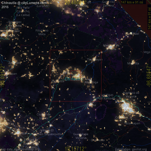
Analysis of Chinautla night lights 2016
Square area 10x10 km:
 1.65%
1.65%90-99
2.07%80-89
4.96%70-79
10.74%60-69
15.5%50-59
4.55%40-49
8.06%30-39
5.79%20-29
16.12%10-19
27.89%0-9
2.69%Square area 50x50 km:
0.14%90-99
0.28%80-89
1.12%70-79
1.28%60-69
2.04%50-59
1.41%40-49
3.03%30-39
2.55%20-29
2.93%10-19
8.56%0-9
76.66%Clear (daylight) street map image can be seen on geolist.org.
Map coordinates:
20° 28' 48.1" North, 98° 5' 30.2" West
19° 49' 11.9" North, 97° 23' 18.9" West
19° 9' 25.6" North, 96° 41' 7.7" West
Some cities around Chinautla sort by population:
• Teziutlan
3 km =1.9 mi,  95°
95°
• Jalacingo
8.6 km =5.3 mi, 102°
• Tlatlauquitepec
11.8 km =7.3 mi,  285°
285°
• Ciudad de Tlatlauquitepec
11.7 km =7.3 mi, 288°
• San Juan Xiutetelco
7.1 km =4.4 mi,  112°
112°
• Atempan
7.6 km =4.7 mi, 286°
• Hueyapán
9.2 km =5.7 mi,  319°
319°
• Atoluca
5.3 km =3.3 mi,  43°
43°
3530907 (p: 11,096)
Sources (retrieved 2019-11-25):
» Earth at Night: Flat Maps 2012, 2016