Hueyapán night lights from space
Night Light of Hueyapán (Puebla) from space (Mexico) Src. Average luminocity for 10x10km area is 21.1667% and for 50x50km: 9.736%.
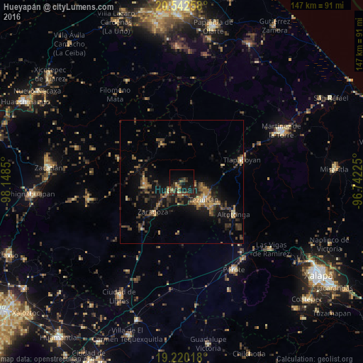
Analysis of Hueyapán night lights 2016
Square area 10x10 km:
 0%
0%90-99
0.22%80-89
2.38%70-79
3.03%60-69
3.9%50-59
1.73%40-49
8.66%30-39
6.28%20-29
8.23%10-19
25.54%0-9
40.04%Square area 50x50 km:
0.11%90-99
0.27%80-89
1.1%70-79
1.22%60-69
1.93%50-59
1.31%40-49
3.16%30-39
2.67%20-29
3.03%10-19
8.54%0-9
76.65%Clear (daylight) street map image can be seen on geolist.org.
Map coordinates:
20° 32' 33.3" North, 98° 8' 54.6" West
19° 52' 57.9" North, 97° 26' 43.3" West
19° 13' 12.6" North, 96° 44' 32.1" West
Some cities around Hueyapán sort by population:
• Teziutlan
11.5 km =7.1 mi,  129°
129°
• Chinautla
9.2 km =5.7 mi,  139°
139°
• Tlatlauquitepec
6.7 km =4.2 mi,  234°
234°
• Ciudad de Tlatlauquitepec
6.2 km =3.9 mi,  237°
237°
• Zacapoaxtla
15.1 km =9.4 mi,  265°
265°
• San Juan Xiutetelco
15.8 km =9.8 mi, 127°
• Atempan
5 km =3.1 mi,  195°
195°
• Atoluca
10.1 km =6.3 mi,  107°
107°
3818645 (p: 6,227)
Sources (retrieved 2019-11-25):
» Earth at Night: Flat Maps 2012, 2016