Huayacocotla night lights from space
Night Light of Huayacocotla (Veracruz) from space (Mexico) Src. Average luminocity for 10x10km area is 2.0246% and for 50x50km: 1.206%.
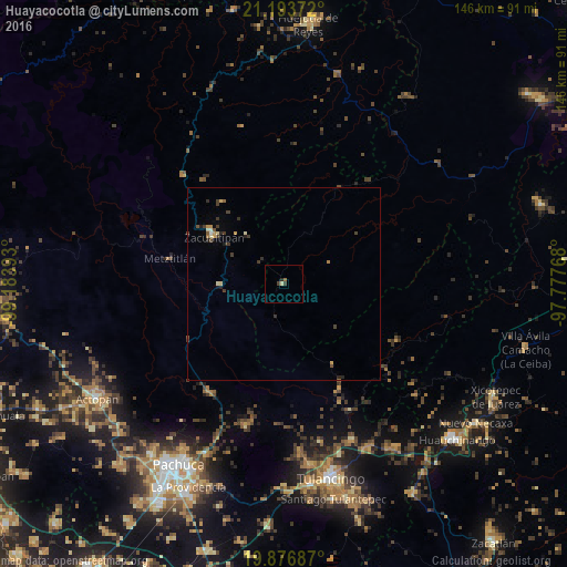
Analysis of Huayacocotla night lights 2016
Square area 10x10 km:
 0%
0%90-99
0.19%80-89
0.57%70-79
0%60-69
0.57%50-59
0.19%40-49
0.19%30-39
1.33%20-29
0.76%10-19
0%0-9
96.21%Square area 50x50 km:
0.01%90-99
0.1%80-89
0.21%70-79
0.19%60-69
0.1%50-59
0.16%40-49
0.18%30-39
0.57%20-29
0.31%10-19
0.11%0-9
98.05%Clear (daylight) street map image can be seen on geolist.org.
Map coordinates:
21° 11' 37.4" North, 99° 11' 2.1" West
20° 32' 12.2" North, 98° 28' 50.9" West
19° 52' 36.7" North, 97° 46' 39.6" West
Some cities around Huayacocotla sort by population:
• Tulancingo
51.9 km =32.2 mi,  166°
166°
• Zacualtipán
22.2 km =13.8 mi,  304°
304°
• Mineral del Monte
48.6 km =30.2 mi,  204°
204°
• Atotonilco el Grande
34 km =21.1 mi,  215°
215°
• Jaltepec
47.3 km =29.4 mi, 171°
• Javier Rojo Gómez
52.3 km =32.5 mi, 172°
• Parque Urbano Napateco
46.2 km =28.7 mi,  161°
161°
• Santa Ana Hueytlalpan
43.9 km =27.3 mi, 156°
3526983 (p: 5,211)
Sources (retrieved 2019-11-25):
» Earth at Night: Flat Maps 2012, 2016