Atotonilco el Grande night lights from space
Night Light of Atotonilco el Grande (Hidalgo) from space (Mexico) Src. Average luminocity for 10x10km area is 6.5496% and for 50x50km: 11.5603%.
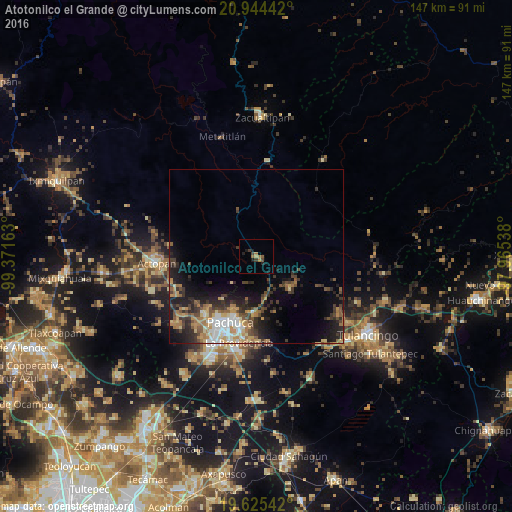
Analysis of Atotonilco el Grande night lights 2016
Square area 10x10 km:
 0%
0%90-99
0%80-89
0%70-79
1.19%60-69
2.38%50-59
1.19%40-49
1.39%30-39
2.18%20-29
1.59%10-19
3.37%0-9
86.71%Square area 50x50 km:
1.27%90-99
1.33%80-89
1.43%70-79
1.75%60-69
2.22%50-59
1.46%40-49
2.21%30-39
2.5%20-29
3.51%10-19
6.38%0-9
75.93%Clear (daylight) street map image can be seen on geolist.org.
Map coordinates:
20° 56' 39.9" North, 99° 22' 17.9" West
20° 17' 10.8" North, 98° 40' 6.6" West
19° 37' 31.5" North, 97° 57' 55.4" West
Some cities around Atotonilco el Grande sort by population:
• Pachuca de Soto
20 km =12.4 mi,  199°
199°
• Actopan
28.8 km =17.9 mi,  266°
266°
• La Providencia Siglo XXI
25.2 km =15.7 mi,  191°
191°
• Mineral del Monte
16.5 km =10.3 mi,  181°
181°
• Campestre Villas del Álamo
20.9 km =13 mi, 191°
• Pachuquilla
24.1 km =15 mi, 186°
• Unidad Minera 11 de Julio
21 km =13 mi, 195°
• Los Tuzos
27.4 km =17 mi, 199°
3532577 (p: 7,261)
Sources (retrieved 2019-11-25):
» Earth at Night: Flat Maps 2012, 2016