Javier Rojo Gómez night lights from space
Night Light of Javier Rojo Gómez (Hidalgo) from space (Mexico) Src. Average luminocity for 10x10km area is 47.1984% and for 50x50km: 13.2174%.
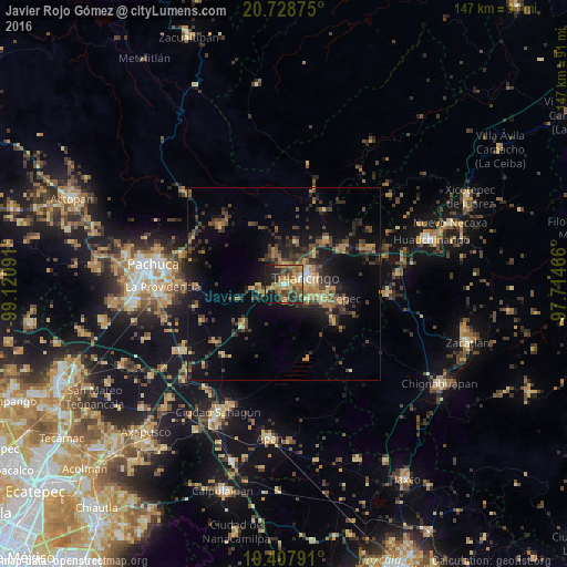
Analysis of Javier Rojo Gómez night lights 2016
Square area 10x10 km:
 1.98%
1.98%90-99
4.56%80-89
2.58%70-79
12.3%60-69
19.05%50-59
9.13%40-49
8.53%30-39
7.54%20-29
10.71%10-19
23.41%0-9
0.2%Square area 50x50 km:
0.22%90-99
0.52%80-89
1.41%70-79
1.92%60-69
2.92%50-59
1.77%40-49
3.51%30-39
3.81%20-29
4.44%10-19
10.39%0-9
69.09%Clear (daylight) street map image can be seen on geolist.org.
Map coordinates:
20° 43' 43.5" North, 99° 7' 15.3" West
20° 4' 11" North, 98° 25' 4" West
19° 24' 28.5" North, 97° 42' 52.8" West
Some cities around Javier Rojo Gómez sort by population:
• Tulancingo
5.9 km =3.7 mi,  74°
74°
• Cuautepec de Hinojosa
11.9 km =7.4 mi,  108°
108°
• Santiago Tulantepec
7.5 km =4.7 mi,  119°
119°
• Mineral del Monte
27.8 km =17.3 mi,  285°
285°
• Jaltepec
5.1 km =3.2 mi,  0°
0°
• Parque Urbano Napateco
11.4 km =7.1 mi,  44°
44°
• Pachuquilla
29 km =18 mi,  270°
270°
• Santa Ana Hueytlalpan
16.1 km =10 mi, 43°
8858225 (p: 6,186)
Sources (retrieved 2019-11-25):
» Earth at Night: Flat Maps 2012, 2016