Parque Urbano Napateco night lights from space
Night Light of Parque Urbano Napateco (Hidalgo) from space (Mexico) Src. Average luminocity for 10x10km area is 36.4821% and for 50x50km: 12.6669%.
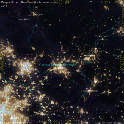
Analysis of Parque Urbano Napateco night lights 2016
Square area 10x10 km:
 0.6%
0.6%90-99
1.59%80-89
4.56%70-79
4.76%60-69
8.93%50-59
7.94%40-49
11.11%30-39
9.72%20-29
16.27%10-19
33.33%0-9
1.19%Square area 50x50 km:
0.22%90-99
0.51%80-89
1.22%70-79
1.9%60-69
3.02%50-59
1.75%40-49
3.6%30-39
3.61%20-29
4.33%10-19
9.34%0-9
70.51%Clear (daylight) street map image can be seen on geolist.org.
Map coordinates:
20° 48' 5.4" North, 99° 2' 38.3" West
20° 8' 34" North, 98° 20' 27" West
19° 28' 52.6" North, 97° 38' 15.8" West
Some cities around Parque Urbano Napateco sort by population:
• Tulancingo
7 km =4.3 mi,  199°
199°
• Huauchinango
30 km =18.6 mi,  83°
83°
• Cuautepec de Hinojosa
12.3 km =7.6 mi,  164°
164°
• Santiago Tulantepec
12 km =7.5 mi,  187°
187°
• Mineral del Monte
34.7 km =21.6 mi,  269°
269°
• Jaltepec
8.5 km =5.3 mi,  249°
249°
• Javier Rojo Gómez
11.4 km =7.1 mi,  224°
224°
• Santa Ana Hueytlalpan
4.7 km =2.9 mi,  40°
40°
8858227 (p: 6,172)
Sources (retrieved 2019-11-25):
» Earth at Night: Flat Maps 2012, 2016