Fraccionamiento Lomas de Ahuatlán night lights from space
Night Light of Fraccionamiento Lomas de Ahuatlán (Morelos) from space (Mexico) Src. Average luminocity for 10x10km area is 61.7468% and for 50x50km: 25.59%.
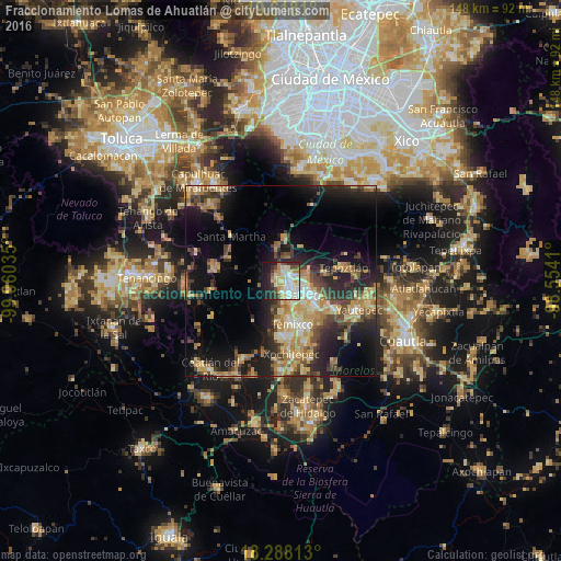
Analysis of Fraccionamiento Lomas de Ahuatlán night lights 2016
Square area 10x10 km:
 8.66%
8.66%90-99
21.21%80-89
12.34%70-79
9.96%60-69
4.76%50-59
2.6%40-49
7.14%30-39
3.46%20-29
13.64%10-19
15.8%0-9
0.43%Square area 50x50 km:
1.34%90-99
3.02%80-89
5.42%70-79
4.59%60-69
4.67%50-59
2.65%40-49
4.93%30-39
4.01%20-29
7.9%10-19
14.58%0-9
46.88%Clear (daylight) street map image can be seen on geolist.org.
Map coordinates:
19° 37' 5.2" North, 99° 57' 37.3" West
18° 57' 16" North, 99° 15' 26" West
18° 17' 17.3" North, 98° 33' 14.8" West
Some cities around Fraccionamiento Lomas de Ahuatlán sort by population:
• Cuernavaca
4.2 km =2.6 mi,  138°
138°
• Jiutepec
11.7 km =7.3 mi,  134°
134°
• Temixco
11.8 km =7.3 mi,  163°
163°
• Emiliano Zapata
14.8 km =9.2 mi,  148°
148°
• Tres de Mayo
10.8 km =6.7 mi, 151°
• Progreso
13.8 km =8.6 mi, 126°
• Tres Marías
11.3 km =7 mi,  7°
7°
• Calera Chica
13.3 km =8.3 mi, 143°
8858171 (p: 8,990)
Sources (retrieved 2019-11-25):
» Earth at Night: Flat Maps 2012, 2016