Benito Juárez night lights from space
Night Light of Benito Juárez (Tlaxcala) from space (Mexico) Src. Average luminocity for 10x10km area is 6.9814% and for 50x50km: 12.5642%.
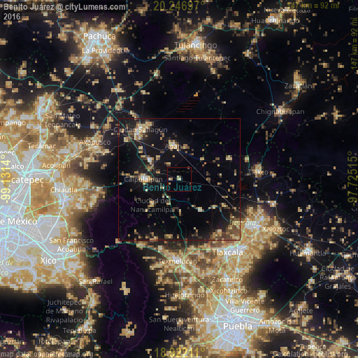
Analysis of Benito Juárez night lights 2016
Square area 10x10 km:
 0%
0%90-99
0.62%80-89
1.86%70-79
1.86%60-69
0.62%50-59
0%40-49
2.07%30-39
0%20-29
0%10-19
0.62%0-9
92.36%Square area 50x50 km:
0.27%90-99
0.46%80-89
2.78%70-79
1.73%60-69
1.5%50-59
1.33%40-49
3.21%30-39
2.62%20-29
2.79%10-19
12.54%0-9
70.76%Clear (daylight) street map image can be seen on geolist.org.
Map coordinates:
20° 14' 49.1" North, 99° 7' 53" West
19° 35' 9.2" North, 98° 25' 41.8" West
18° 55' 19.6" North, 97° 43' 30.5" West
Some cities around Benito Juárez sort by population:
• Calpulalpan
14.8 km =9.2 mi,  271°
271°
• Ciudad Sahagun
26.1 km =16.2 mi,  323°
323°
• Apan
14.1 km =8.8 mi,  350°
350°
• Tepeapulco
26 km =16.2 mi,  329°
329°
• Ciudad de Nanacamilpa
15.3 km =9.5 mi,  227°
227°
• Emiliano Zapata
14.4 km =8.9 mi,  302°
302°
• Villa Mariano Matamoros
29.3 km =18.2 mi,  169°
169°
• Jaltepec
26.9 km =16.7 mi,  306°
306°
3815030 (p: 5,674)
Sources (retrieved 2019-11-25):
» Earth at Night: Flat Maps 2012, 2016