Ciudad de Nanacamilpa night lights from space
Night Light of Ciudad de Nanacamilpa (Tlaxcala) from space (Mexico) Src. Average luminocity for 10x10km area is 11.6136% and for 50x50km: 16.5986%.
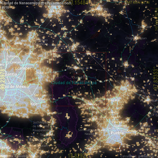
Analysis of Ciudad de Nanacamilpa night lights 2016
Square area 10x10 km:
 0%
0%90-99
0%80-89
3.51%70-79
1.03%60-69
1.86%50-59
0.62%40-49
1.03%30-39
3.31%20-29
2.69%10-19
2.48%0-9
83.47%Square area 50x50 km:
0.37%90-99
0.84%80-89
3.87%70-79
2.54%60-69
2.79%50-59
1.87%40-49
3.89%30-39
3.13%20-29
4.78%10-19
13.08%0-9
62.85%Clear (daylight) street map image can be seen on geolist.org.
Map coordinates:
20° 9' 17.4" North, 99° 14' 23.2" West
19° 29' 36.2" North, 98° 32' 11.9" West
18° 49' 45.2" North, 97° 50' 0.7" West
Some cities around Ciudad de Nanacamilpa sort by population:
• Calpulalpan
11.1 km =6.9 mi,  341°
341°
• San Matias Tlalancaleca
19.1 km =11.9 mi,  167°
167°
• Emiliano Zapata
18 km =11.2 mi,  357°
357°
• San Lucas el Grande
21.7 km =13.5 mi,  163°
163°
• Santa Rita Tlahuapan
18.4 km =11.4 mi,  193°
193°
• San Jerónimo Amanalco
23.2 km =14.4 mi,  276°
276°
• Río Frío de Juárez
21 km =13 mi,  222°
222°
• Benito Juárez
15.3 km =9.5 mi,  47°
47°
3522855 (p: 12,177)
Sources (retrieved 2019-11-25):
» Earth at Night: Flat Maps 2012, 2016