Coatepec night lights from space
Night Light of Coatepec (México) from space (Mexico) Src. Average luminocity for 10x10km area is 61.345% and for 50x50km: 54.7453%.
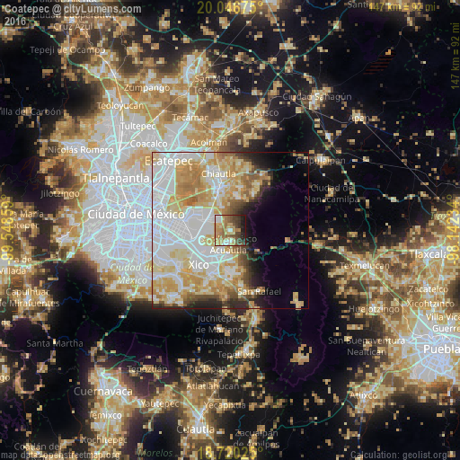
Analysis of Coatepec night lights 2016
Square area 10x10 km:
 6.82%
6.82%90-99
5.99%80-89
10.74%70-79
17.15%60-69
16.74%50-59
8.26%40-49
13.22%30-39
8.88%20-29
7.44%10-19
4.75%0-9
0%Square area 50x50 km:
17.9%90-99
10.64%80-89
10.49%70-79
9.94%60-69
6.08%50-59
3.07%40-49
3.34%30-39
2.65%20-29
3.95%10-19
4.74%0-9
27.21%Clear (daylight) street map image can be seen on geolist.org.
Map coordinates:
20° 2' 48.3" North, 99° 32' 54.9" West
19° 23' 5.5" North, 98° 50' 43.7" West
18° 43' 12.9" North, 98° 8' 32.4" West
Some cities around Coatepec sort by population:
• Ixtapaluca
8.6 km =5.3 mi,  206°
206°
• Chicoloapan
6.9 km =4.3 mi,  300°
300°
• San Buenaventura
9.3 km =5.8 mi,  191°
191°
• San Francisco Acuautla
4.6 km =2.9 mi,  199°
199°
• San Miguel Coatlinchán
7.8 km =4.8 mi,  338°
338°
• Lomas de San Sebastián
9.2 km =5.7 mi,  268°
268°
• Santiago Cuautlalpan
7.9 km =4.9 mi,  311°
311°
• Jorge Jiménez Cantú
8.4 km =5.2 mi,  180°
180°
3817676 (p: 8,841)
Sources (retrieved 2019-11-25):
» Earth at Night: Flat Maps 2012, 2016