Tamulte de las Sabanas night lights from space
Night Light of Tamulte de las Sabanas (Tabasco) from space (Mexico) Src. Average luminocity for 10x10km area is 24.2641% and for 50x50km: 15.2302%.
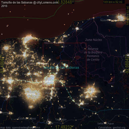
Analysis of Tamulte de las Sabanas night lights 2016
Square area 10x10 km:
 2.6%
2.6%90-99
3.46%80-89
2.6%70-79
2.81%60-69
4.11%50-59
2.6%40-49
3.46%30-39
3.46%20-29
3.9%10-19
30.09%0-9
40.91%Square area 50x50 km:
2.38%90-99
2.8%80-89
2.62%70-79
1.05%60-69
1.42%50-59
2.14%40-49
2.41%30-39
2.99%20-29
4.05%10-19
9.17%0-9
68.97%Clear (daylight) street map image can be seen on geolist.org.
Map coordinates:
18° 49' 42.5" North, 93° 29' 12" West
18° 9' 42" North, 92° 47' 0.7" West
17° 29' 32.4" North, 92° 4' 49.5" West
Some cities around Tamulte de las Sabanas sort by population:
• Villahermosa
24.9 km =15.5 mi,  218°
218°
• Nacajuca
24.8 km =15.4 mi,  272°
272°
• Pomoca
19.9 km =12.4 mi,  231°
231°
• Bosque de Saloya
24.5 km =15.2 mi, 228°
• Villa Vicente Guerrero
28 km =17.4 mi,  334°
334°
• Medellín y Madero Segunda Sección
9.2 km =5.7 mi, 234°
• La Selva
24.4 km =15.2 mi, 230°
• Macultepec
8.3 km =5.2 mi,  261°
261°
3516344 (p: 8,824)
Sources (retrieved 2019-11-25):
» Earth at Night: Flat Maps 2012, 2016