Brisas Barra de Suchiate night lights from space
Night Light of Brisas Barra de Suchiate (Chiapas) from space (Mexico) Src. Average luminocity for 10x10km area is 1.2684% and for 50x50km: 1.799%.
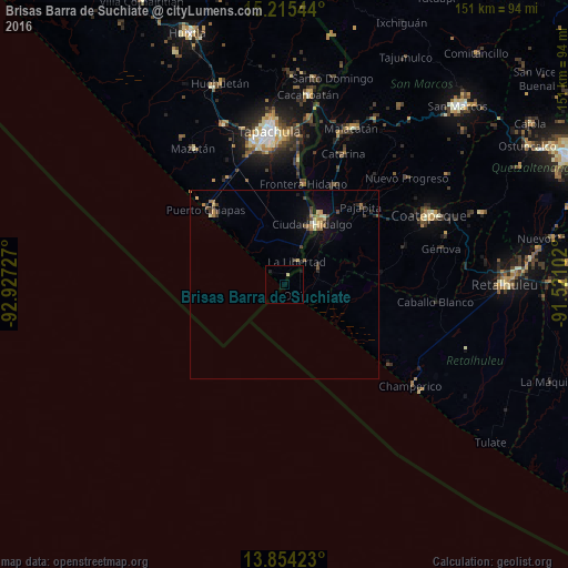
Analysis of Brisas Barra de Suchiate night lights 2016
Square area 10x10 km:
 0%
0%90-99
0%80-89
0.87%70-79
0%60-69
0%50-59
0%40-49
0%30-39
0%20-29
0.87%10-19
0.87%0-9
97.4%Square area 50x50 km:
0%90-99
0.15%80-89
0.39%70-79
0.21%60-69
0.39%50-59
0.19%40-49
0.38%30-39
0.29%20-29
0.28%10-19
0.91%0-9
96.81%Clear (daylight) street map image can be seen on geolist.org.
Map coordinates:
15° 12' 55.6" North, 92° 55' 38.2" West
14° 32' 9.2" North, 92° 13' 26.9" West
13° 51' 15.2" North, 91° 31' 15.7" West
Some cities around Brisas Barra de Suchiate sort by population:
• Tapachula
41.1 km =25.5 mi,  354°
354°
• Ciudad Hidalgo
17.9 km =11.1 mi,  25°
25°
• Flores Costa Cuca, GT
40.3 km =25 mi,  74°
74°
• Ciudad Tecún Umán, GT
18.1 km =11.2 mi, 29°
• Puerto Madero
29.6 km =18.4 mi,  314°
314°
• Ocós, GT
4.4 km =2.7 mi,  130°
130°
• Pajapita, GT
29 km =18 mi,  44°
44°
• Vida Mejor I
38.2 km =23.7 mi, 346°
3516497 (p: 13,743)
Sources (retrieved 2019-11-25):
» Earth at Night: Flat Maps 2012, 2016