La Libertad night lights from space
Night Light of La Libertad (Huehuetenango) from space (Guatemala) Src. Average luminocity for 10x10km area is 0% and for 50x50km: 0.4958%.
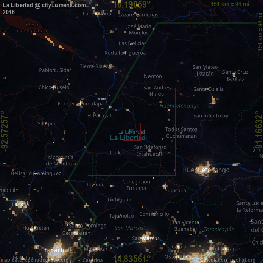
Analysis of La Libertad night lights 2016
Square area 10x10 km:
 0%
0%90-99
0%80-89
0%70-79
0%60-69
0%50-59
0%40-49
0%30-39
0%20-29
0%10-19
0%0-9
100%Square area 50x50 km:
0%90-99
0%80-89
0.03%70-79
0.05%60-69
0.08%50-59
0.06%40-49
0.25%30-39
0.31%20-29
0.13%10-19
0.18%0-9
98.9%Clear (daylight) street map image can be seen on geolist.org.
Map coordinates:
16° 11' 26.1" North, 92° 34' 21.3" West
15° 30' 51.2" North, 91° 52' 10" West
14° 50' 8.2" North, 91° 9' 58.8" West
Some cities around La Libertad sort by population:
• Huehuetenango
47.8 km =29.7 mi,  117°
117°
• Jacaltenango
23.9 km =14.9 mi,  44°
44°
• Motozintla, MX
43.6 km =27.1 mi,  247°
247°
• Comalapa, MX
33.4 km =20.8 mi,  298°
298°
• Concepción Huista
25 km =15.5 mi,  60°
60°
• Chiantla
47.5 km =29.5 mi,  111°
111°
• Tacaná
37.1 km =23.1 mi,  214°
214°
• San Antonio Huista
18.4 km =11.4 mi,  34°
34°
3594423 (p: 6,439)
Sources (retrieved 2019-11-25):
» Earth at Night: Flat Maps 2012, 2016