Santo Tomás Chautla night lights from space
Night Light of Santo Tomás Chautla (Puebla) from space (Mexico) Src. Average luminocity for 10x10km area is 70.8571% and for 50x50km: 41.7666%.
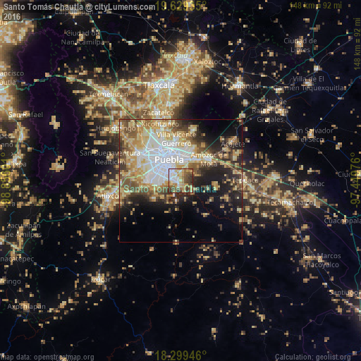
Analysis of Santo Tomás Chautla night lights 2016
Square area 10x10 km:
 11.9%
11.9%90-99
16.88%80-89
14.07%70-79
11.9%60-69
9.31%50-59
12.12%40-49
11.47%30-39
10.82%20-29
1.52%10-19
0%0-9
0%Square area 50x50 km:
9.1%90-99
6.25%80-89
8.95%70-79
6.72%60-69
4.57%50-59
5.1%40-49
6.09%30-39
4.89%20-29
6.76%10-19
10.73%0-9
30.83%Clear (daylight) street map image can be seen on geolist.org.
Map coordinates:
19° 37' 45.7" North, 98° 51' 21.6" West
18° 57' 56.6" North, 98° 9' 10.4" West
18° 17' 58.1" North, 97° 26' 59.1" West
Some cities around Santo Tomás Chautla sort by population:
• Puebla
9.6 km =6 mi,  326°
326°
• Amozoc de Mota
14.4 km =8.9 mi,  51°
51°
• San Bernardino Tlaxcalancingo
14.8 km =9.2 mi,  298°
298°
• Casa Blanca
9.2 km =5.7 mi,  22°
22°
• Santa María Xonacatepec
14.7 km =9.1 mi, 20°
• La Resurrección
15.4 km =9.6 mi,  8°
8°
• San Andrés Azumiatla
12.5 km =7.8 mi,  236°
236°
• San Sebastián de Aparicio
15.3 km =9.5 mi,  356°
356°
3516818 (p: 6,540)
Sources (retrieved 2019-11-25):
» Earth at Night: Flat Maps 2012, 2016