Ayapango night lights from space
Night Light of Ayapango (México) from space (Mexico) Src. Average luminocity for 10x10km area is 44.3268% and for 50x50km: 31.2251%.
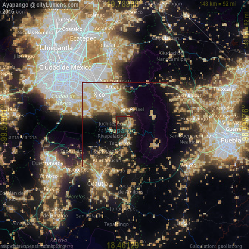
Analysis of Ayapango night lights 2016
Square area 10x10 km:
 0.43%
0.43%90-99
3.25%80-89
9.31%70-79
8.23%60-69
13.64%50-59
4.33%40-49
8.44%30-39
5.41%20-29
31.6%10-19
15.37%0-9
0%Square area 50x50 km:
5.03%90-99
4.58%80-89
6.12%70-79
5.97%60-69
4.71%50-59
2.4%40-49
4.22%30-39
3.23%20-29
7.03%10-19
12.9%0-9
43.8%Clear (daylight) street map image can be seen on geolist.org.
Map coordinates:
19° 47' 23.6" North, 99° 30' 10.8" West
19° 7' 36.9" North, 98° 47' 59.6" West
18° 27' 40.6" North, 98° 5' 48.3" West
Some cities around Ayapango sort by population:
• Amecameca
3.5 km =2.2 mi,  95°
95°
• San Rafael
10.3 km =6.4 mi,  26°
26°
• Ozumba de Alzate
10 km =6.2 mi,  177°
177°
• Juchitepec
8.8 km =5.5 mi,  250°
250°
• Tlalmanalco
8.7 km =5.4 mi,  359°
359°
• San Juan Tehuixtitlán
8.8 km =5.5 mi,  156°
156°
• San Matías Cuijingo
7.3 km =4.5 mi,  230°
230°
• Tenango del Aire
6.9 km =4.3 mi,  299°
299°
3532525 (p: 6,361)
Sources (retrieved 2019-11-25):
» Earth at Night: Flat Maps 2012, 2016