Tlalmanalco night lights from space
Night Light of Tlalmanalco (México) from space (Mexico) Src. Average luminocity for 10x10km area is 51.8745% and for 50x50km: 34.163%.
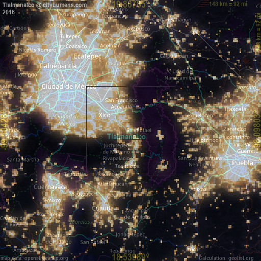
Analysis of Tlalmanalco night lights 2016
Square area 10x10 km:
 2.6%
2.6%90-99
5.41%80-89
8.01%70-79
11.47%60-69
11.47%50-59
9.52%40-49
14.29%30-39
9.09%20-29
24.46%10-19
3.68%0-9
0%Square area 50x50 km:
8.72%90-99
5.93%80-89
5.85%70-79
5.94%60-69
4.17%50-59
2.21%40-49
3.38%30-39
2.49%20-29
5.36%10-19
11.1%0-9
44.85%Clear (daylight) street map image can be seen on geolist.org.
Map coordinates:
19° 52' 4.3" North, 99° 30' 15.4" West
19° 12' 18.8" North, 98° 48' 4.1" West
18° 32' 23.6" North, 98° 5' 52.9" West
Some cities around Tlalmanalco sort by population:
• San Rafael
4.7 km =2.9 mi,  84°
84°
• San Gregorio Cuautzingo
8.5 km =5.3 mi,  315°
315°
• Santa María Huexoculco
6.2 km =3.9 mi,  340°
340°
• Miraflores
2 km =1.2 mi, 340°
• Cocotitlán
7.5 km =4.7 mi,  294°
294°
• Tenango del Aire
7.9 km =4.9 mi,  227°
227°
• Temamatla
7.2 km =4.5 mi,  268°
268°
• La Candelaria Tlapala
6.3 km =3.9 mi,  308°
308°
3515438 (p: 14,786)
Sources (retrieved 2019-11-25):
» Earth at Night: Flat Maps 2012, 2016