Ozumba de Alzate night lights from space
Night Light of Ozumba de Alzate (México) from space (Mexico) Src. Average luminocity for 10x10km area is 41.7922% and for 50x50km: 27.2942%.
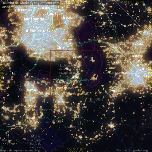
Analysis of Ozumba de Alzate night lights 2016
Square area 10x10 km:
 2.38%
2.38%90-99
6.06%80-89
9.09%70-79
6.06%60-69
7.58%50-59
5.19%40-49
4.33%30-39
2.38%20-29
28.35%10-19
28.35%0-9
0.22%Square area 50x50 km:
1.53%90-99
2.46%80-89
5.12%70-79
6.16%60-69
5.94%50-59
3.24%40-49
5.14%30-39
3.71%20-29
7.73%10-19
14.59%0-9
44.38%Clear (daylight) street map image can be seen on geolist.org.
Map coordinates:
19° 42' 0.8" North, 99° 29' 53.8" West
19° 2' 12.8" North, 98° 47' 42.6" West
18° 22' 15.2" North, 98° 5' 31.3" West
Some cities around Ozumba de Alzate sort by population:
• Amecameca
10.1 km =6.3 mi,  17°
17°
• Juchitepec
11.3 km =7 mi,  308°
308°
• Tepetlixpa
2.9 km =1.8 mi,  252°
252°
• Atlautla
2.4 km =1.5 mi,  133°
133°
• Ecatzingo de Hidalgo
10.2 km =6.3 mi,  153°
153°
• San Juan Tehuixtitlán
3.5 km =2.2 mi,  56°
56°
• Ayapango
10 km =6.2 mi,  357°
357°
• San Matías Cuijingo
8.1 km =5 mi, 311°
3522232 (p: 16,700)
Sources (retrieved 2019-11-25):
» Earth at Night: Flat Maps 2012, 2016