San Juan Tehuixtitlán night lights from space
Night Light of San Juan Tehuixtitlán (México) from space (Mexico) Src. Average luminocity for 10x10km area is 37.1342% and for 50x50km: 26.3059%.
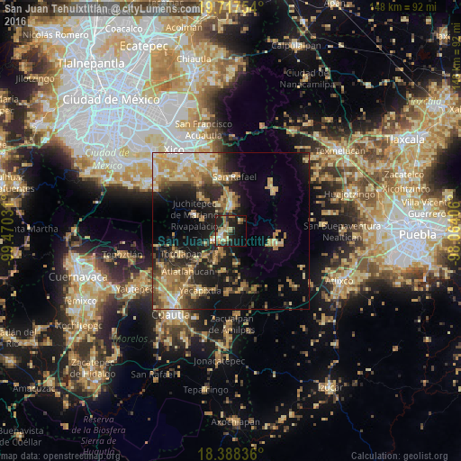
Analysis of San Juan Tehuixtitlán night lights 2016
Square area 10x10 km:
 1.3%
1.3%90-99
4.98%80-89
8.87%70-79
4.11%60-69
9.52%50-59
4.55%40-49
3.68%30-39
3.46%20-29
21%10-19
24.03%0-9
14.5%Square area 50x50 km:
1.62%90-99
2.42%80-89
5.07%70-79
5.88%60-69
5.62%50-59
2.93%40-49
4.77%30-39
3.48%20-29
6.92%10-19
14.22%0-9
47.07%Clear (daylight) street map image can be seen on geolist.org.
Map coordinates:
19° 43' 3.1" North, 99° 28' 13.1" West
19° 3' 15.4" North, 98° 46' 1.8" West
18° 23' 18.1" North, 98° 3' 50.6" West
Some cities around San Juan Tehuixtitlán sort by population:
• Amecameca
7.7 km =4.8 mi,  0°
0°
• Ozumba de Alzate
3.5 km =2.2 mi,  236°
236°
• Juchitepec
12.8 km =8 mi,  293°
293°
• Tepetlixpa
6.3 km =3.9 mi, 243°
• Atlautla
3.8 km =2.4 mi,  198°
198°
• Ecatzingo de Hidalgo
11.1 km =6.9 mi,  171°
171°
• Ayapango
8.8 km =5.5 mi,  336°
336°
• San Matías Cuijingo
9.6 km =6 mi, 290°
3817610 (p: 6,743)
Sources (retrieved 2019-11-25):
» Earth at Night: Flat Maps 2012, 2016