Atotonilco de Tula night lights from space
Night Light of Atotonilco de Tula (Hidalgo) from space (Mexico) Src. Average luminocity for 10x10km area is 66.0377% and for 50x50km: 34.2245%.
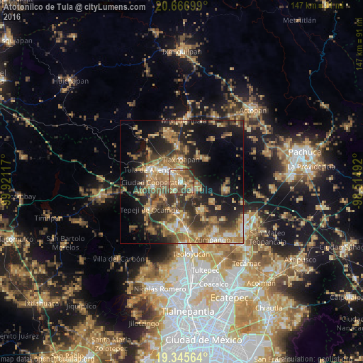
Analysis of Atotonilco de Tula night lights 2016
Square area 10x10 km:
 5.95%
5.95%90-99
6.94%80-89
9.92%70-79
19.25%60-69
25.6%50-59
10.52%40-49
11.31%30-39
7.94%20-29
2.58%10-19
0%0-9
0%Square area 50x50 km:
1.97%90-99
2.84%80-89
5.13%70-79
6.45%60-69
9.76%50-59
5.43%40-49
6.65%30-39
7.18%20-29
10.12%10-19
15.69%0-9
28.78%Clear (daylight) street map image can be seen on geolist.org.
Map coordinates:
20° 40' 1.2" North, 99° 55' 16.2" West
20° 0' 27.7" North, 99° 13' 4.9" West
19° 20' 44.3" North, 98° 30' 53.7" West
Some cities around Atotonilco de Tula sort by population:
• El Llano
12.4 km =7.7 mi,  301°
301°
• Tlaxcoapan
9.3 km =5.8 mi,  358°
358°
• Apaxco de Ocampo
6.1 km =3.8 mi,  126°
126°
• San Marcos
12.5 km =7.8 mi,  281°
281°
• Cardonal
5.6 km =3.5 mi,  346°
346°
• San Miguel Vindho
10.5 km =6.5 mi,  261°
261°
• Doxey
9.7 km =6 mi,  344°
344°
• Atitalaquia
5.8 km =3.6 mi, 356°
3532576 (p: 8,154)
Sources (retrieved 2019-11-25):
» Earth at Night: Flat Maps 2012, 2016