Antúnez night lights from space
Night Light of Antúnez (Michoacán) from space (Mexico) Src. Average luminocity for 10x10km area is 5.329% and for 50x50km: 2.8716%.
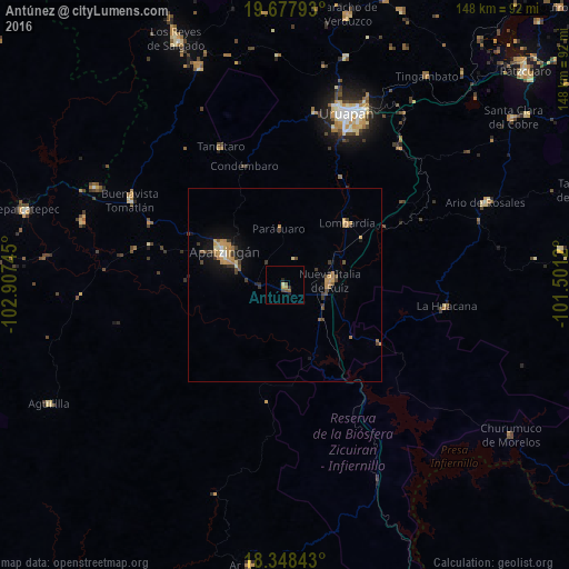
Analysis of Antúnez night lights 2016
Square area 10x10 km:
 0%
0%90-99
0.43%80-89
0.65%70-79
1.52%60-69
0%50-59
1.95%40-49
1.52%30-39
0.65%20-29
1.08%10-19
0.87%0-9
91.34%Square area 50x50 km:
0%90-99
0.22%80-89
0.28%70-79
0.87%60-69
0.48%50-59
0.38%40-49
0.58%30-39
0.71%20-29
0.21%10-19
1.62%0-9
94.65%Clear (daylight) street map image can be seen on geolist.org.
Map coordinates:
19° 40' 40.5" North, 102° 54' 26.8" West
19° 0' 52.2" North, 102° 12' 15.6" West
18° 20' 54.3" North, 101° 30' 4.3" West
Some cities around Antúnez sort by population:
• Apatzingán
18 km =11.2 mi,  297°
297°
• Nueva Italia de Ruiz
11.7 km =7.3 mi,  84°
84°
• Nuevo San Juan Parangaricutiro
45.6 km =28.3 mi,  9°
9°
• La Mira Tumbiscatio
37.8 km =23.5 mi,  192°
192°
• Lombardía
22.7 km =14.1 mi,  45°
45°
• Buenavista Tomatlán
45.9 km =28.5 mi, 298°
• La Huacana
42.1 km =26.2 mi,  97°
97°
• Tancítaro
39.7 km =24.7 mi,  335°
335°
4018430 (p: 8,591)
Sources (retrieved 2019-11-25):
» Earth at Night: Flat Maps 2012, 2016