Nuevo San Juan Parangaricutiro night lights from space
Night Light of Nuevo San Juan Parangaricutiro (Michoacán) from space (Mexico) Src. Average luminocity for 10x10km area is 11.624% and for 50x50km: 5.3402%.
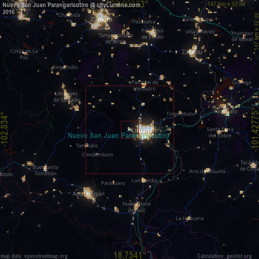
Analysis of Nuevo San Juan Parangaricutiro night lights 2016
Square area 10x10 km:
 0%
0%90-99
0.62%80-89
1.45%70-79
1.03%60-69
1.65%50-59
1.03%40-49
0.41%30-39
1.86%20-29
8.26%10-19
21.9%0-9
61.78%Square area 50x50 km:
0.62%90-99
0.8%80-89
0.93%70-79
0.6%60-69
0.63%50-59
0.36%40-49
0.97%30-39
0.84%20-29
1.61%10-19
3.4%0-9
89.25%Clear (daylight) street map image can be seen on geolist.org.
Map coordinates:
20° 4' 49.2" North, 102° 50' 2.4" West
19° 25' 6.9" North, 102° 7' 51.1" West
18° 45' 14.8" North, 101° 25' 39.9" West
Some cities around Nuevo San Juan Parangaricutiro sort by population:
• Uruapan
7.8 km =4.8 mi,  96°
96°
• Paracho de Verduzco
26.9 km =16.7 mi,  18°
18°
• Lombardía
30.2 km =18.8 mi,  163°
163°
• Capácuaro
16.5 km =10.3 mi,  30°
30°
• Tancítaro
25.9 km =16.1 mi,  249°
249°
• Taretán
24.2 km =15 mi,  112°
112°
• Angahuán
17.5 km =10.9 mi,  325°
325°
• Caltzontzín
13 km =8.1 mi,  87°
87°
3994594 (p: 14,772)
Sources (retrieved 2019-11-25):
» Earth at Night: Flat Maps 2012, 2016