Pailles night lights from space
Night Light of Pailles (Moka) from space (Mauritius) Src. Average luminocity for 10x10km area is 73.996% and for 50x50km: 17.0442%.
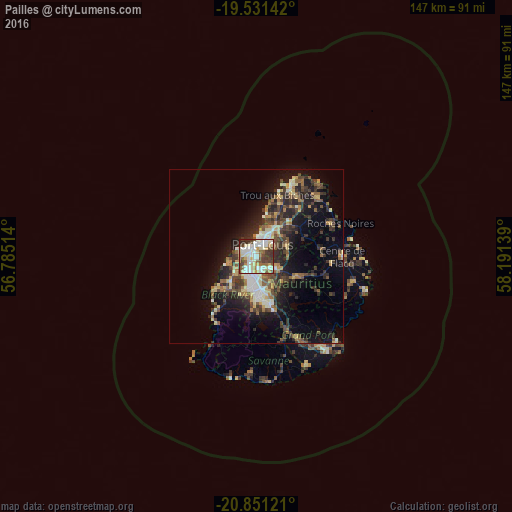
Analysis of Pailles night lights 2016
Square area 10x10 km:
 17.86%
90-99
24.4%80-89
11.9%70-79
5.95%60-69
4.96%50-59
9.52%40-49
11.11%30-39
9.92%20-29
4.17%10-19
0.2%0-9
0%Square area 50x50 km:
1.62%90-99
2.89%80-89
2.34%70-79
1.65%60-69
1.93%50-59
2.22%40-49
3.65%30-39
3.91%20-29
5.84%10-19
9.54%0-9
64.4%Clear (daylight) street map image can be seen on geolist.org.
Map coordinates:
19° 31' 53.1" South, 56° 47' 6.5" East
20° 11' 33.8" South, 57° 29' 17.7" East
20° 51' 4.4" South, 58° 11' 29" East
Some cities around Pailles sort by population:
• Port Louis
3.6 km =2.2 mi,  17°
17°
• Beau Bassin-Rose Hill
5.1 km =3.2 mi,  207°
207°
• Quatre Bornes
8 km =5 mi,  186°
186°
• Saint Pierre
4.4 km =2.7 mi,  129°
129°
• Le Hochet
7.3 km =4.5 mi,  28°
28°
• Terre Rouge
8.3 km =5.2 mi, 27°
• Moka
3 km =1.9 mi,  164°
164°
• Petite Rivière
4.4 km =2.7 mi,  265°
265°
934219 (p: 10,622)
Sources (retrieved 2019-11-25):
» Earth at Night: Flat Maps 2012, 2016