Moka night lights from space
Night Light of Moka from space (Mauritius) Src. Average luminocity for 10x10km area is 71.9603% and for 50x50km: 17.6931%.
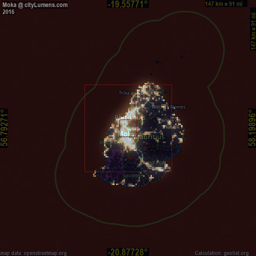
Analysis of Moka night lights 2016
Square area 10x10 km:
 16.27%
90-99
21.43%80-89
11.9%70-79
6.15%60-69
4.17%50-59
12.9%40-49
12.3%30-39
10.52%20-29
4.37%10-19
0%0-9
0%Square area 50x50 km:
1.66%90-99
2.95%80-89
2.38%70-79
1.76%60-69
2.09%50-59
2.42%40-49
3.82%30-39
4.19%20-29
6.05%10-19
9.35%0-9
63.33%Clear (daylight) street map image can be seen on geolist.org.
Map coordinates:
19° 33' 27.8" South, 56° 47' 33.8" East
20° 13' 8" South, 57° 29' 45" East
20° 52' 38.2" South, 58° 11' 56.3" East
Some cities around Moka sort by population:
• Port Louis
6.3 km =3.9 mi,  2°
2°
• Beau Bassin-Rose Hill
3.5 km =2.2 mi,  242°
242°
• Vacoas
9 km =5.6 mi,  191°
191°
• Quatre Bornes
5.3 km =3.3 mi,  199°
199°
• Saint Pierre
2.6 km =1.6 mi,  86°
86°
• Pailles
3 km =1.9 mi,  344°
344°
• Dagotière
7.5 km =4.7 mi,  112°
112°
• Petite Rivière
5.8 km =3.6 mi,  296°
296°
934277 (p: 8,842)
Sources (retrieved 2019-11-25):
» Earth at Night: Flat Maps 2012, 2016