Għaxaq night lights from space
Night Light of Għaxaq (Ħal Għaxaq) from space (Malta) Src. Average luminocity for 10x10km area is 77.3094% and for 50x50km: 9.7177%.
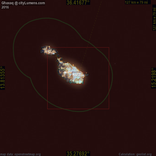
Analysis of Għaxaq night lights 2016
Square area 10x10 km:
100  23.25%
90-99 25.35%
80-89 11.54%
70-79 11.71%
60-69 6.29%
50-59 2.27%
40-49 2.1%
30-39 4.37%
20-29 10.66%
10-19 2.45%
0-9 0%
23.25%90-99
25.35%80-89
11.54%70-79
11.71%60-69
6.29%50-59
2.27%40-49
2.1%30-39
4.37%20-29
10.66%10-19
2.45%0-9
0%Square area 50x50 km:
100 1.77%
90-99 1.97%
80-89 1.02%
70-79 1.34%
60-69 1.78%
50-59 0.55%
40-49 1%
30-39 1.26%
20-29 2.52%
10-19 5.3%
0-9 81.49%
1.77%90-99
1.97%80-89
1.02%70-79
1.34%60-69
1.78%50-59
0.55%40-49
1%30-39
1.26%20-29
2.52%10-19
5.3%0-9
81.49%Clear (daylight) street map image can be seen on geolist.org.
Map coordinates:
36° 25' 0.4" North, 13° 48' 48.8" East
35° 50' 56" North, 14° 31' 0" East
35° 16' 36.9" North, 15° 13' 11.3" East
Some cities around Għaxaq sort by population:
• Fgura
2.4 km =1.5 mi,  352°
352°
• Żejtun
1.7 km =1.1 mi,  62°
62°
• Birżebbuġa
2.7 km =1.7 mi,  160°
160°
• Tarxien
1.9 km =1.2 mi,  355°
355°
• Luqa
2.8 km =1.7 mi,  293°
293°
• Marsaxlokk
2.5 km =1.6 mi,  107°
107°
• Gudja
1.2 km =0.7 mi,  271°
271°
• Kirkop
2.9 km =1.8 mi,  255°
255°
2563046 (p: 4,375)
Sources (retrieved 2019-11-25):
» Earth at Night: Flat Maps 2012, 2016