Ilinden night lights from space
Night Light of Ilinden from space (North Macedonia) Src. Average luminocity for 10x10km area is 43.7254% and for 50x50km: 11.3109%.
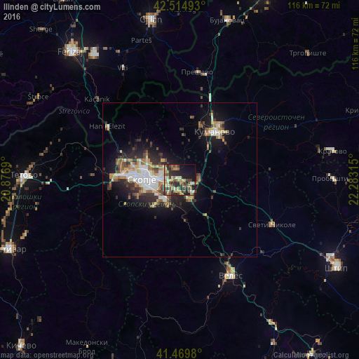
Analysis of Ilinden night lights 2016
Square area 10x10 km:
 1.59%
1.59%90-99
7.78%80-89
5.71%70-79
7.62%60-69
9.37%50-59
7.78%40-49
9.21%30-39
6.98%20-29
17.14%10-19
18.1%0-9
8.73%Square area 50x50 km:
1.5%90-99
2.07%80-89
1.2%70-79
1.09%60-69
1.97%50-59
1.5%40-49
1.6%30-39
1.93%20-29
3.32%10-19
6.98%0-9
76.84%Clear (daylight) street map image can be seen on geolist.org.
Map coordinates:
42° 30' 53.7" North, 20° 52' 36.8" East
41° 59' 40.2" North, 21° 34' 48.1" East
41° 28' 11.3" North, 22° 16' 59.3" East
Some cities around Ilinden sort by population:
• Čair
11.7 km =7.3 mi,  281°
281°
• Kisela Voda
8.2 km =5.1 mi,  231°
231°
• Butel
11.7 km =7.3 mi,  290°
290°
• Studeničane
8.9 km =5.5 mi,  204°
204°
• Арачиново
3.8 km =2.4 mi,  337°
337°
• Dračevo
8 km =5 mi,  216°
216°
• Петровец
6.8 km =4.2 mi,  154°
154°
• Zelenikovo
12.3 km =7.6 mi,  176°
176°
833357 (p: 16,406)
Sources (retrieved 2019-11-25):
» Earth at Night: Flat Maps 2012, 2016