Studeničane night lights from space
Night Light of Studeničane (Studenichani) from space (North Macedonia) Src. Average luminocity for 10x10km area is 28.0778% and for 50x50km: 11.1545%.
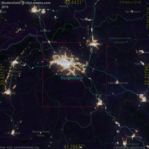
Analysis of Studeničane night lights 2016
Square area 10x10 km:
 1.27%
1.27%90-99
4.13%80-89
3.81%70-79
3.17%60-69
2.86%50-59
5.71%40-49
6.98%30-39
5.87%20-29
10%10-19
21.9%0-9
34.29%Square area 50x50 km:
1.49%90-99
2.1%80-89
1.25%70-79
1.1%60-69
1.88%50-59
1.56%40-49
1.52%30-39
1.83%20-29
3.2%10-19
6.38%0-9
77.7%Clear (daylight) street map image can be seen on geolist.org.
Map coordinates:
42° 26' 35.2" North, 20° 49' 54.2" East
41° 55' 19.5" North, 21° 32' 5.4" East
41° 23' 48.4" North, 22° 14' 16.7" East
Some cities around Studeničane sort by population:
• Skopje
11.9 km =7.4 mi,  314°
314°
• Kisela Voda
4 km =2.5 mi,  318°
318°
• Ilinden
8.9 km =5.5 mi,  24°
24°
• Арачиново
11.8 km =7.3 mi,  10°
10°
• Dračevo
2 km =1.2 mi,  326°
326°
• Сопиште
9.6 km =6 mi,  292°
292°
• Петровец
6.9 km =4.3 mi,  74°
74°
• Zelenikovo
6.1 km =3.8 mi,  133°
133°
785345 (p: 18,219)
Sources (retrieved 2019-11-25):
» Earth at Night: Flat Maps 2012, 2016