Gradsko night lights from space
Night Light of Gradsko from space (North Macedonia) Src. Average luminocity for 10x10km area is 5.1088% and for 50x50km: 3.1159%.
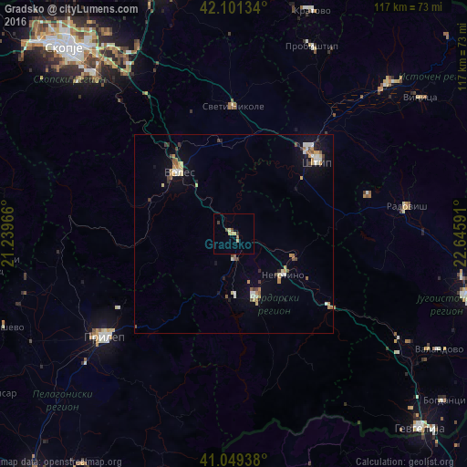
Analysis of Gradsko night lights 2016
Square area 10x10 km:
 0%
0%90-99
0.16%80-89
1.95%70-79
1.14%60-69
0%50-59
0.65%40-49
1.3%30-39
0.97%20-29
0.32%10-19
0%0-9
93.51%Square area 50x50 km:
0.16%90-99
0.62%80-89
0.48%70-79
0.46%60-69
0.36%50-59
0.42%40-49
0.32%30-39
0.38%20-29
0.26%10-19
1.23%0-9
95.32%Clear (daylight) street map image can be seen on geolist.org.
Map coordinates:
42° 6' 4.8" North, 21° 14' 22.8" East
41° 34' 39" North, 21° 56' 34" East
41° 2' 57.8" North, 22° 38' 45.3" East
Some cities around Gradsko sort by population:
• Veles
20.7 km =12.9 mi,  317°
317°
• Shtip
28.1 km =17.5 mi,  48°
48°
• Kavadarci
17.1 km =10.6 mi,  160°
160°
• Negotino
16.1 km =10 mi,  130°
130°
• Demir Kapija
31.7 km =19.7 mi, 127°
• Rosoman
6.8 km =4.2 mi,  177°
177°
• Čaška
24.7 km =15.3 mi,  289°
289°
• Lozovo
23.2 km =14.4 mi,  352°
352°
790217 (p: 3,737)
Sources (retrieved 2019-11-25):
» Earth at Night: Flat Maps 2012, 2016