Pervomaisc night lights from space
Night Light of Pervomaisc (Transnistria) from space (Moldova) Src. Average luminocity for 10x10km area is 1.1429% and for 50x50km: 1.515%.
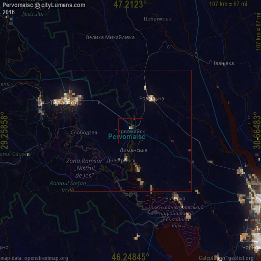
Analysis of Pervomaisc night lights 2016
Square area 10x10 km:
 0%
0%90-99
0%80-89
0.6%70-79
0%60-69
0%50-59
0%40-49
0.6%30-39
0.3%20-29
0.6%10-19
0%0-9
97.92%Square area 50x50 km:
0.04%90-99
0.14%80-89
0.12%70-79
0.2%60-69
0.25%50-59
0.34%40-49
0.44%30-39
0.31%20-29
0.37%10-19
0.73%0-9
97.07%Clear (daylight) street map image can be seen on geolist.org.
Map coordinates:
47° 12' 44.3" North, 29° 15' 30.9" East
46° 43' 57.1" North, 29° 57' 42.1" East
46° 14' 54.4" North, 30° 39' 53.4" East
Some cities around Pervomaisc sort by population:
• Tiraspol
28.1 km =17.5 mi,  295°
295°
• Rozdil’na, UA
15.2 km =9.4 mi,  35°
35°
• Slobozia
19.6 km =12.2 mi,  268°
268°
• Bilyayivka, UA
33.9 km =21.1 mi,  144°
144°
• Dnestrovsc
13.3 km =8.3 mi,  194°
194°
• Chiţcani
26.9 km =16.7 mi,  282°
282°
• Lymanske, UA
8.6 km =5.3 mi,  177°
177°
• Ştefan Vodă
33.5 km =20.8 mi,  223°
223°
617602 (p: 7,300)
Sources (retrieved 2019-11-25):
» Earth at Night: Flat Maps 2012, 2016