Midar night lights from space
Night Light of Midar (Oriental) from space (Morocco) Src. Average luminocity for 10x10km area is 18.9029% and for 50x50km: 5.1645%.
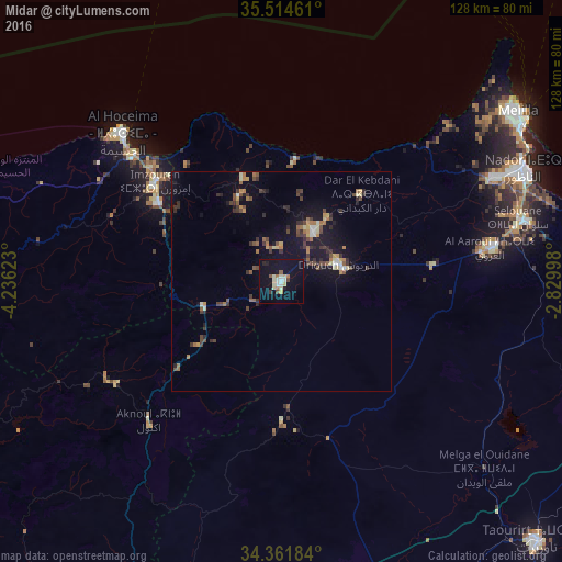
Analysis of Midar night lights 2016
Square area 10x10 km:
 0.73%
0.73%90-99
5.49%80-89
3.3%70-79
1.28%60-69
1.65%50-59
1.47%40-49
1.28%30-39
0.92%20-29
1.47%10-19
19.05%0-9
63.37%Square area 50x50 km:
0.17%90-99
0.57%80-89
0.58%70-79
0.51%60-69
0.83%50-59
0.65%40-49
1.11%30-39
1.24%20-29
0.98%10-19
4.3%0-9
89.06%Clear (daylight) street map image can be seen on geolist.org.
Map coordinates:
35° 30' 52.6" North, 4° 14' 10.4" West
34° 56' 24.9" North, 3° 31' 59.2" West
34° 21' 42.6" North, 2° 49' 47.9" West
Some cities around Midar sort by population:
• Al Hoceïma
50.5 km =31.4 mi,  313°
313°
• Nador
60.2 km =37.4 mi,  65°
65°
• Melilla, ES
66.9 km =41.6 mi,  54°
54°
• Tirhanimîne
50.5 km =31.4 mi, 310°
• Imzouren
36.9 km =22.9 mi, 308°
• Al Aaroui
48.4 km =30.1 mi,  80°
80°
• Bni Bouayach
33.4 km =20.8 mi,  303°
303°
• Targuist
71.6 km =44.5 mi,  269°
269°
2542230 (p: 10,229)
Sources (retrieved 2019-11-25):
» Earth at Night: Flat Maps 2012, 2016