Bni Bouayach night lights from space
Night Light of Bni Bouayach (Tanger-Tetouan-Al Hoceima) from space (Morocco) Src. Average luminocity for 10x10km area is 25.9388% and for 50x50km: 5.0269%.
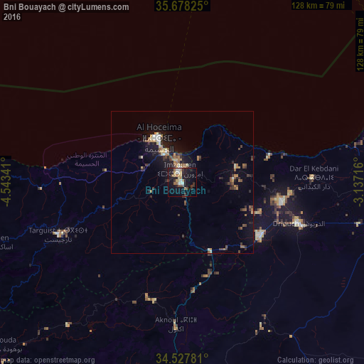
Analysis of Bni Bouayach night lights 2016
Square area 10x10 km:
 1.92%
1.92%90-99
4.37%80-89
3.85%70-79
2.8%60-69
5.24%50-59
1.4%40-49
3.85%30-39
3.85%20-29
4.37%10-19
31.82%0-9
36.54%Square area 50x50 km:
0.3%90-99
0.55%80-89
0.55%70-79
0.55%60-69
0.89%50-59
0.73%40-49
0.81%30-39
1.05%20-29
0.98%10-19
4.61%0-9
88.98%Clear (daylight) street map image can be seen on geolist.org.
Map coordinates:
35° 40' 41.7" North, 4° 32' 36.3" West
35° 6' 18.2" North, 3° 50' 25" West
34° 31' 40.1" North, 3° 8' 13.8" West
Some cities around Bni Bouayach sort by population:
• Al Hoceïma
18.5 km =11.5 mi,  331°
331°
• Nador
82.7 km =51.4 mi,  85°
85°
• Melilla, ES
84.6 km =52.6 mi,  75°
75°
• Tirhanimîne
17.9 km =11.1 mi,  324°
324°
• Imzouren
4.7 km =2.9 mi,  348°
348°
• Al Aaroui
76.3 km =47.4 mi,  97°
97°
• Targuist
47.4 km =29.5 mi,  246°
246°
• Midar
33.4 km =20.8 mi,  123°
123°
10958491 (p: 18,271)
Sources (retrieved 2019-11-25):
» Earth at Night: Flat Maps 2012, 2016