Olaine night lights from space
Night Light of Olaine from space (Latvia) Src. Average luminocity for 10x10km area is 7.7881% and for 50x50km: 12.7269%.
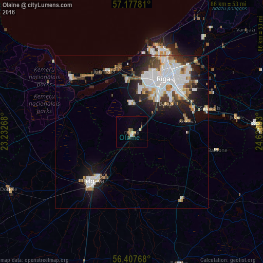
Analysis of Olaine night lights 2016
Square area 10x10 km:
100  0.36%
0.36%
90-99 0.83%
80-89 1.19%
70-79 1.19%
60-69 1.67%
50-59 1.43%
40-49 0.95%
30-39 0.24%
20-29 1.19%
10-19 0%
0-9 90.95%
0.36%90-99
0.83%80-89
1.19%70-79
1.19%60-69
1.67%50-59
1.43%40-49
0.95%30-39
0.24%20-29
1.19%10-19
0%0-9
90.95%Square area 50x50 km:
100 3.64%
90-99 2.98%
80-89 0.89%
70-79 0.95%
60-69 1.19%
50-59 1.12%
40-49 1.24%
30-39 1.48%
20-29 2.65%
10-19 5.7%
0-9 78.15%
3.64%90-99
2.98%80-89
0.89%70-79
0.95%60-69
1.19%50-59
1.12%40-49
1.24%30-39
1.48%20-29
2.65%10-19
5.7%0-9
78.15%Clear (daylight) street map image can be seen on geolist.org.
Map coordinates:
57° 10' 40.1" North, 23° 13' 57.6" East
56° 47' 41" North, 23° 56' 8.9" East
56° 24' 27.6" North, 24° 38' 20.1" East
Some cities around Olaine sort by population:
• Riga
19.7 km =12.2 mi,  31°
31°
• Jelgava
21.1 km =13.1 mi,  220°
220°
• Jūrmala
21.7 km =13.5 mi,  332°
332°
• Salaspils
27.1 km =16.8 mi,  74°
74°
• Ķekava
18.3 km =11.4 mi,  78°
78°
• Ozolnieki
15.2 km =9.4 mi, 219°
• Piņķi
16.4 km =10.2 mi,  355°
355°
• Mārupe
14.2 km =8.8 mi, 29°
457052 (p: 12,584)
Sources (retrieved 2019-11-25):
» Earth at Night: Flat Maps 2012, 2016