Ozolnieki night lights from space
Night Light of Ozolnieki (Ozolnieku) from space (Latvia) Src. Average luminocity for 10x10km area is 15.9012% and for 50x50km: 3.5694%.
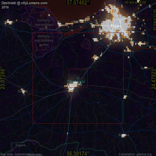
Analysis of Ozolnieki night lights 2016
Square area 10x10 km:
 3.57%
3.57%90-99
5.24%80-89
1.07%70-79
0.48%60-69
1.07%50-59
1.31%40-49
1.07%30-39
1.07%20-29
2.02%10-19
13.93%0-9
69.17%Square area 50x50 km:
0.6%90-99
0.76%80-89
0.25%70-79
0.39%60-69
0.31%50-59
0.28%40-49
0.41%30-39
0.52%20-29
0.94%10-19
2.94%0-9
92.61%Clear (daylight) street map image can be seen on geolist.org.
Map coordinates:
57° 4' 26.5" North, 23° 4' 22.7" East
56° 41' 23.5" North, 23° 46' 34" East
56° 18' 6.3" North, 24° 28' 45.2" East
Some cities around Ozolnieki sort by population:
• Jelgava
5.9 km =3.7 mi,  221°
221°
• Jūrmala
30.9 km =19.2 mi,  359°
359°
• Olaine
15.2 km =9.4 mi,  39°
39°
• Dobele
31.5 km =19.6 mi,  256°
256°
• Ķekava
31.6 km =19.6 mi,  61°
61°
• Iecava
28.3 km =17.6 mi,  111°
111°
• Piņķi
29.2 km =18.1 mi,  16°
16°
• Mārupe
29.2 km =18.1 mi,  34°
34°
456954 (p: 3,400)
Sources (retrieved 2019-11-25):
» Earth at Night: Flat Maps 2012, 2016