Salaspils night lights from space
Night Light of Salaspils from space (Latvia) Src. Average luminocity for 10x10km area is 9.0881% and for 50x50km: 11.9326%.
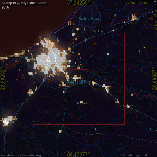
Analysis of Salaspils night lights 2016
Square area 10x10 km:
100  0.24%
0.24%
90-99 1.19%
80-89 2.38%
70-79 0%
60-69 0.95%
50-59 1.79%
40-49 0.83%
30-39 0.48%
20-29 0.24%
10-19 8.45%
0-9 83.45%
0.24%90-99
1.19%80-89
2.38%70-79
0%60-69
0.95%50-59
1.79%40-49
0.83%30-39
0.48%20-29
0.24%10-19
8.45%0-9
83.45%Square area 50x50 km:
100 3.58%
90-99 2.81%
80-89 0.95%
70-79 0.91%
60-69 0.94%
50-59 1.1%
40-49 1.01%
30-39 1.45%
20-29 2.88%
10-19 4.61%
0-9 79.75%
3.58%90-99
2.81%80-89
0.95%70-79
0.91%60-69
0.94%50-59
1.1%40-49
1.01%30-39
1.45%20-29
2.88%10-19
4.61%0-9
79.75%Clear (daylight) street map image can be seen on geolist.org.
Map coordinates:
57° 14' 33.2" North, 23° 39' 44.4" East
56° 51' 36.5" North, 24° 21' 55.6" East
56° 28' 25.6" North, 25° 4' 6.9" East
Some cities around Salaspils sort by population:
• Riga
18.4 km =11.4 mi,  301°
301°
• Ogre
15.9 km =9.9 mi,  107°
107°
• Ķekava
9 km =5.6 mi,  245°
245°
• Ikšķile
8.5 km =5.3 mi, 110°
• Ulbroka
9.3 km =5.8 mi,  336°
336°
• Baldone
13 km =8.1 mi,  170°
170°
• Mārupe
19.7 km =12.2 mi,  284°
284°
• Berģi
14.6 km =9.1 mi, 344°
455898 (p: 17,606)
Sources (retrieved 2019-11-25):
» Earth at Night: Flat Maps 2012, 2016