Mārupe night lights from space
Night Light of Mārupe from space (Latvia) Src. Average luminocity for 10x10km area is 63.892% and for 50x50km: 13.1935%.
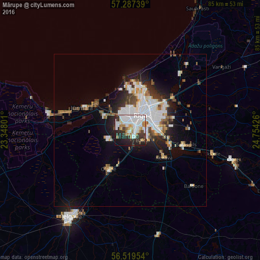
Analysis of Mārupe night lights 2016
Square area 10x10 km:
100  26.02%
90-99 16.7%
80-89 3.41%
70-79 4.77%
60-69 6.59%
50-59 1.36%
40-49 2.73%
30-39 10%
20-29 15.11%
10-19 11.7%
0-9 1.59%
26.02%90-99
16.7%80-89
3.41%70-79
4.77%60-69
6.59%50-59
1.36%40-49
2.73%30-39
10%20-29
15.11%10-19
11.7%0-9
1.59%Square area 50x50 km:
100 3.68%
90-99 2.91%
80-89 0.95%
70-79 0.93%
60-69 1.23%
50-59 1.41%
40-49 1.28%
30-39 1.62%
20-29 3.03%
10-19 5.75%
0-9 77.2%
3.68%90-99
2.91%80-89
0.95%70-79
0.93%60-69
1.23%50-59
1.41%40-49
1.28%30-39
1.62%20-29
3.03%10-19
5.75%0-9
77.2%Clear (daylight) street map image can be seen on geolist.org.
Map coordinates:
57° 17' 14.6" North, 23° 20' 52.8" East
56° 54' 19.6" North, 24° 3' 4.1" East
56° 31' 10.3" North, 24° 45' 15.3" East
Some cities around Mārupe sort by population:
• Riga
5.6 km =3.5 mi,  36°
36°
• Bolderaja
14 km =8.7 mi,  1°
1°
• Olaine
14.2 km =8.8 mi,  209°
209°
• Daugavgrīva
15.3 km =9.5 mi,  356°
356°
• Ķekava
14 km =8.7 mi,  128°
128°
• Piņķi
9.3 km =5.8 mi,  295°
295°
• Ulbroka
15.7 km =9.8 mi,  77°
77°
• Berģi
17.5 km =10.9 mi,  59°
59°
864723 (p: 0)
Sources (retrieved 2019-11-25):
» Earth at Night: Flat Maps 2012, 2016