Tasböget night lights from space
Night Light of Tasböget (Qyzylorda) from space (Kazakhstan) Src. Average luminocity for 10x10km area is 46.3364% and for 50x50km: 4.9976%.
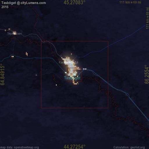
Analysis of Tasböget night lights 2016
Square area 10x10 km:
 7.88%
7.88%90-99
12.88%80-89
6.36%70-79
4.85%60-69
6.52%50-59
5%40-49
4.24%30-39
1.82%20-29
15.15%10-19
24.09%0-9
11.21%Square area 50x50 km:
0.9%90-99
1.29%80-89
0.52%70-79
0.5%60-69
0.55%50-59
0.4%40-49
0.3%30-39
0.43%20-29
1.69%10-19
3.43%0-9
89.99%Clear (daylight) street map image can be seen on geolist.org.
Map coordinates:
45° 16' 15" North, 64° 50' 56.9" East
44° 46' 25.8" North, 65° 33' 8.2" East
44° 16' 21.1" North, 66° 15' 19.4" East
Some cities around Tasböget sort by population:
• Kyzylorda
9.4 km =5.8 mi,  338°
338°
• Baikonur
198.7 km =123.5 mi,  298°
298°
• Shīeli
115.7 km =71.9 mi,  125°
125°
• Yanykurgan
165.7 km =103 mi, 125°
• Zhosaly
140.3 km =87.2 mi, 304°
• Dzhalagash
77.7 km =48.3 mi, 296°
• Terenozek
54.3 km =33.7 mi, 304°
• Tyuratam
200.7 km =124.7 mi, 299°
1518431 (p: 16,455)
Sources (retrieved 2019-11-25):
» Earth at Night: Flat Maps 2012, 2016