Lenger night lights from space
Night Light of Lenger (South Kazakhstan) from space (Kazakhstan) Src. Average luminocity for 10x10km area is 0.7364% and for 50x50km: 5.3525%.
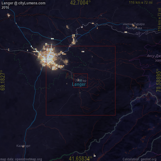

Analysis of Lenger night lights 2016
Square area 10x10 km:
 0%
0%90-99
0%80-89
0%70-79
0%60-69
0%50-59
0%40-49
0.61%30-39
0%20-29
1.21%10-19
0.61%0-9
97.58%Square area 50x50 km:
0.88%90-99
1.08%80-89
0.68%70-79
0.7%60-69
0.71%50-59
0.65%40-49
0.63%30-39
0.92%20-29
1.39%10-19
2.45%0-9
89.91%Clear (daylight) street map image can be seen on geolist.org.
Map coordinates:
42° 42' 1.4" North, 69° 10' 57.7" East
42° 10' 53.5" North, 69° 53' 9" East
41° 39' 30" North, 70° 35' 20.2" East
Some cities around Lenger sort by population:
• Shymkent
27 km =16.8 mi,  299°
299°
• Belyye Vody
27.2 km =16.9 mi,  349°
349°
• G‘azalkent, UZ
70 km =43.5 mi,  187°
187°
• Turar Ryskulov
54.6 km =33.9 mi,  44°
44°
• Leninskoye
62.9 km =39.1 mi,  221°
221°
• Temirlanovka
69.4 km =43.1 mi,  312°
312°
• Tyul’kubas
47.8 km =29.7 mi, 44°
• Sastobe
42.4 km =26.3 mi,  12°
12°
1521379 (p: 21,238)
Sources (retrieved 2019-11-25):
» Earth at Night: Flat Maps 2012, 2016