Janūb as Surrah night lights from space
Night Light of Janūb as Surrah (Al Farwaniyah) from space (Kuwait) Src. Average luminocity for 10x10km area is 99.1307% and for 50x50km: 56.1301%.
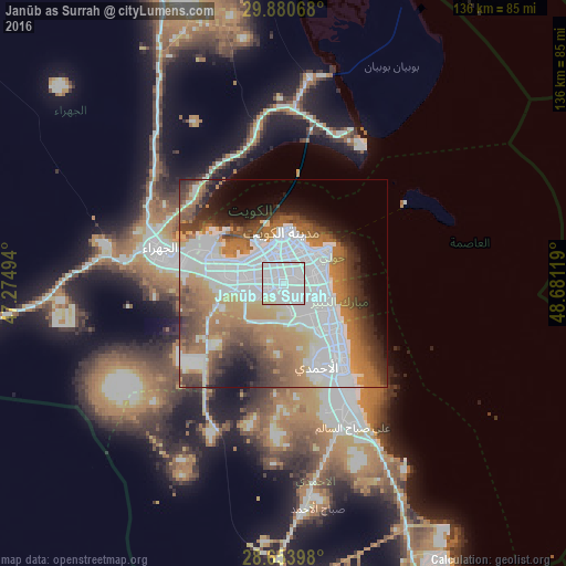
Analysis of Janūb as Surrah night lights 2016
Square area 10x10 km:
 85.8%
85.8%90-99
9.09%80-89
5.11%70-79
0%60-69
0%50-59
0%40-49
0%30-39
0%20-29
0%10-19
0%0-9
0%Square area 50x50 km:
22.75%90-99
8.74%80-89
3.2%70-79
5.83%60-69
10.97%50-59
6.49%40-49
6.38%30-39
5.56%20-29
4.82%10-19
6.02%0-9
19.24%Clear (daylight) street map image can be seen on geolist.org.
Map coordinates:
29° 52' 50.4" North, 47° 16' 29.8" East
29° 16' 9" North, 47° 58' 41" East
28° 39' 14.3" North, 48° 40' 52.3" East
Some cities around Janūb as Surrah sort by population:
• Ḩawallī
8.6 km =5.3 mi,  34°
34°
• Şabāḩ as Sālim
7.8 km =4.8 mi,  99°
99°
• Al Farwānīyah
2.1 km =1.3 mi,  296°
296°
• Ar Rumaythīyah
10.4 km =6.5 mi,  63°
63°
• Salwá
10.2 km =6.3 mi,  73°
73°
• Ar Rābiyah
5.2 km =3.2 mi, 303°
• Bayān
7.8 km =4.8 mi, 61°
• Ash Shāmīyah
8.8 km =5.5 mi,  349°
349°
285603 (p: 18,496)
Sources (retrieved 2019-11-25):
» Earth at Night: Flat Maps 2012, 2016