Mubārak al Kabīr night lights from space
Night Light of Mubārak al Kabīr from space (Kuwait) Src. Average luminocity for 10x10km area is 95.9921% and for 50x50km: 51.1551%.
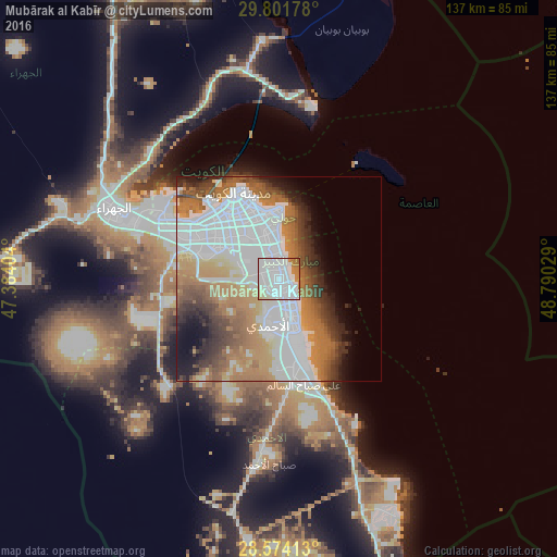
Analysis of Mubārak al Kabīr night lights 2016
Square area 10x10 km:
 66.47%
90-99
18.85%80-89
5.95%70-79
4.37%60-69
4.37%50-59
0%40-49
0%30-39
0%20-29
0%10-19
0%0-9
0%Square area 50x50 km:
20.96%90-99
7.7%80-89
2.7%70-79
6.28%60-69
10.72%50-59
5.33%40-49
4.61%30-39
4.83%20-29
4.49%10-19
5.34%0-9
27.03%Clear (daylight) street map image can be seen on geolist.org.
Map coordinates:
29° 48' 6.4" North, 47° 23' 2.5" East
29° 11' 23.2" North, 48° 5' 13.8" East
28° 34' 26.9" North, 48° 47' 25" East
Some cities around Mubārak al Kabīr sort by population:
• Al Aḩmadī
12.6 km =7.8 mi,  181°
181°
• Şabāḩ as Sālim
8 km =5 mi,  338°
338°
• Al Faḩāḩīl
12.6 km =7.8 mi,  160°
160°
• Ar Riqqah
4.9 km =3 mi,  171°
171°
• Salwá
11.8 km =7.3 mi,  355°
355°
• Al Manqaf
11.3 km =7 mi, 156°
• Al Finţās
3.7 km =2.3 mi,  118°
118°
• Al Mahbūlah
6.5 km =4 mi,  139°
139°
7329411 (p: 0)
Sources (retrieved 2019-11-25):
» Earth at Night: Flat Maps 2012, 2016