Suluktu night lights from space
Night Light of Suluktu (Batken) from space (Kyrgyzstan) Src. Average luminocity for 10x10km area is 1.9048% and for 50x50km: 0.7474%.
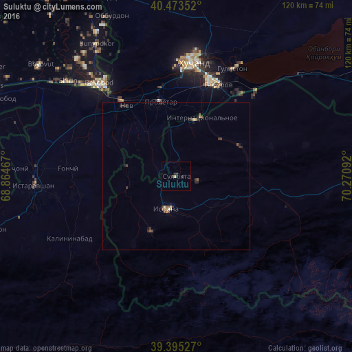
Analysis of Suluktu night lights 2016
Square area 10x10 km:
 0%
0%90-99
0%80-89
0.68%70-79
0%60-69
0%50-59
0%40-49
0%30-39
1.36%20-29
2.04%10-19
0%0-9
95.92%Square area 50x50 km:
0%90-99
0.07%80-89
0.14%70-79
0.03%60-69
0.05%50-59
0.18%40-49
0.16%30-39
0.31%20-29
0.31%10-19
0.16%0-9
98.58%Clear (daylight) street map image can be seen on geolist.org.
Map coordinates:
40° 28' 24.7" North, 68° 51' 52.8" East
39° 56' 11.5" North, 69° 34' 4" East
39° 23' 43" North, 70° 16' 15.3" East
Some cities around Suluktu sort by population:
• Khŭjand, TJ
38.8 km =24.1 mi,  6°
6°
• Bekobod, UZ
40.5 km =25.2 mi,  321°
321°
• Istaravshan, TJ
48.2 km =30 mi,  267°
267°
• Chkalov, TJ
34.8 km =21.6 mi,  18°
18°
• Isfana
11.4 km =7.1 mi,  197°
197°
• Proletar, TJ
26.3 km =16.3 mi,  347°
347°
• Nov, TJ
29.3 km =18.2 mi,  325°
325°
• Konsoy, TJ
62.8 km =39 mi, 10°
1222562 (p: 15,019)
Sources (retrieved 2019-11-25):
» Earth at Night: Flat Maps 2012, 2016