Isfana night lights from space
Night Light of Isfana (Batken) from space (Kyrgyzstan) Src. Average luminocity for 10x10km area is 7.5289% and for 50x50km: 0.5342%.
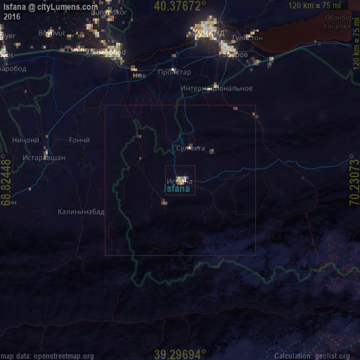
Analysis of Isfana night lights 2016
Square area 10x10 km:
 0%
0%90-99
1.87%80-89
0.85%70-79
0.68%60-69
1.36%50-59
2.04%40-49
1.87%30-39
0.85%20-29
0%10-19
0.68%0-9
89.8%Square area 50x50 km:
0%90-99
0.07%80-89
0.06%70-79
0.03%60-69
0.05%50-59
0.15%40-49
0.15%30-39
0.21%20-29
0.15%10-19
0.08%0-9
99.04%Clear (daylight) street map image can be seen on geolist.org.
Map coordinates:
40° 22' 36.2" North, 68° 49' 28.1" East
39° 50' 20.2" North, 69° 31' 39.4" East
39° 17' 49" North, 70° 13' 50.6" East
Some cities around Isfana sort by population:
• Khŭjand, TJ
50 km =31.1 mi,  9°
9°
• Bekobod, UZ
47.8 km =29.7 mi,  332°
332°
• Istaravshan, TJ
45.5 km =28.3 mi,  280°
280°
• Chkalov, TJ
46.2 km =28.7 mi,  17°
17°
• Proletar, TJ
36.6 km =22.7 mi,  356°
356°
• Suluktu
11.4 km =7.1 mi, 17°
• Nov, TJ
37.3 km =23.2 mi,  339°
339°
• Konsoy, TJ
74.1 km =46 mi, 11°
1222662 (p: 16,952)
Sources (retrieved 2019-11-25):
» Earth at Night: Flat Maps 2012, 2016