Kara Suu night lights from space
Night Light of Kara Suu (Osh) from space (Kyrgyzstan) Src. Average luminocity for 10x10km area is 26.4107% and for 50x50km: 11.798%.
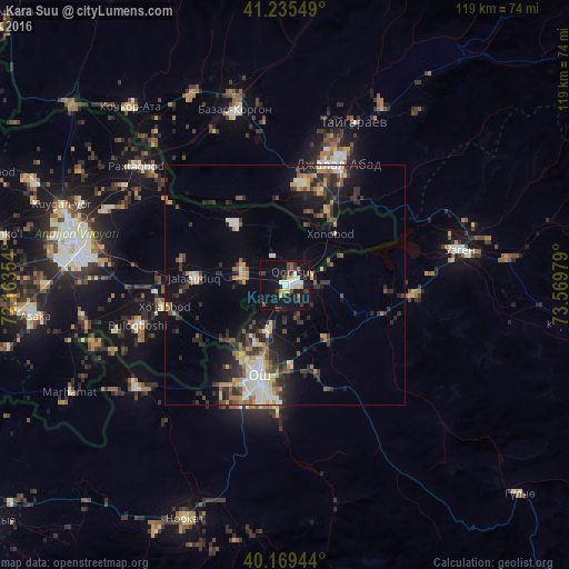
Analysis of Kara Suu night lights 2016
Square area 10x10 km:
 3.9%
3.9%90-99
5.36%80-89
2.92%70-79
1.95%60-69
0.49%50-59
2.92%40-49
4.22%30-39
4.87%20-29
3.9%10-19
41.23%0-9
28.25%Square area 50x50 km:
1.36%90-99
1.79%80-89
1.2%70-79
1.35%60-69
1.34%50-59
1.52%40-49
1.6%30-39
2.86%20-29
4.04%10-19
7.34%0-9
75.61%Clear (daylight) street map image can be seen on geolist.org.
Map coordinates:
41° 14' 7.8" North, 72° 9' 48.7" East
40° 42' 16.6" North, 72° 51' 60" East
40° 10' 10" North, 73° 34' 11.2" East
Some cities around Kara Suu sort by population:
• Andijon, UZ
44.8 km =27.8 mi,  281°
281°
• Osh
20.4 km =12.7 mi,  196°
196°
• Jalal-Abad
27.8 km =17.3 mi,  23°
23°
• Uzgen
37.3 km =23.2 mi,  78°
78°
• Bazar-Korgon
38.4 km =23.9 mi,  344°
344°
• Qo‘rg‘ontepa, UZ
9.3 km =5.8 mi,  288°
288°
• Xo‘jaobod, UZ
26.2 km =16.3 mi,  261°
261°
• Kochkor-Ata
49.1 km =30.5 mi,  318°
318°
1528091 (p: 17,800)
Sources (retrieved 2019-11-25):
» Earth at Night: Flat Maps 2012, 2016