Kochkor-Ata night lights from space
Night Light of Kochkor-Ata (Jalal-Abad) from space (Kyrgyzstan) Src. Average luminocity for 10x10km area is 11.8401% and for 50x50km: 7.8048%.
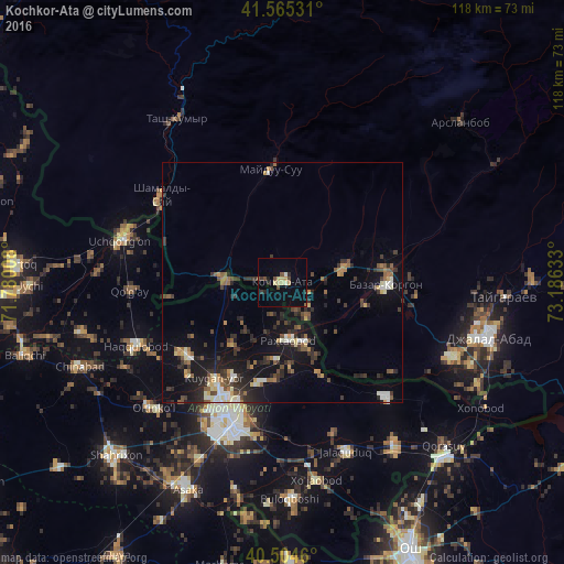
Analysis of Kochkor-Ata night lights 2016
Square area 10x10 km:
 0%
0%90-99
1.36%80-89
3.4%70-79
1.36%60-69
0%50-59
0.51%40-49
3.4%30-39
1.36%20-29
2.38%10-19
1.02%0-9
85.2%Square area 50x50 km:
0.53%90-99
1.02%80-89
0.85%70-79
0.71%60-69
0.8%50-59
1.29%40-49
1.37%30-39
1.85%20-29
2.5%10-19
6.35%0-9
82.72%Clear (daylight) street map image can be seen on geolist.org.
Map coordinates:
41° 33' 55.1" North, 71° 46' 48.3" East
41° 2' 13.5" North, 72° 28' 59.5" East
40° 30' 16.6" North, 73° 11' 10.8" East
Some cities around Kochkor-Ata sort by population:
• Andijon, UZ
30.7 km =19.1 mi,  202°
202°
• Jalal-Abad
44.9 km =27.9 mi,  104°
104°
• Uchqŭrghon Shahri, UZ
34.9 km =21.7 mi,  284°
284°
• Bazar-Korgon
22 km =13.7 mi,  89°
89°
• Haqqulobod, UZ
33.6 km =20.9 mi,  246°
246°
• Qo‘rg‘ontepa, UZ
41.2 km =25.6 mi,  145°
145°
• Tash-Kumyr
40.9 km =25.4 mi,  327°
327°
• Xo‘jaobod, UZ
41.4 km =25.7 mi,  171°
171°
1527903 (p: 14,814)
Sources (retrieved 2019-11-25):
» Earth at Night: Flat Maps 2012, 2016