Sobue night lights from space
Night Light of Sobue (Aichi) from space (Japan) Src. Average luminocity for 10x10km area is 52.7972% and for 50x50km: 54.162%.
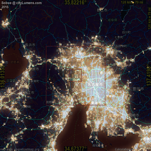
Analysis of Sobue night lights 2016
Square area 10x10 km:
100  0.52%
0.52%
90-99 3.67%
80-89 7.52%
70-79 6.82%
60-69 14.86%
50-59 26.22%
40-49 12.94%
30-39 11.54%
20-29 15.73%
10-19 0.17%
0-9 0%
0.52%90-99
3.67%80-89
7.52%70-79
6.82%60-69
14.86%50-59
26.22%40-49
12.94%30-39
11.54%20-29
15.73%10-19
0.17%0-9
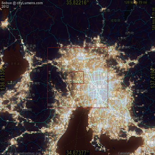
0%Square area 50x50 km:
100 14.41%
90-99 10.9%
80-89 5.89%
70-79 7.06%
60-69 9.44%
50-59 9.38%
40-49 6.36%
30-39 5.25%
20-29 7.65%
10-19 5.43%
0-9 18.22%
14.41%90-99
10.9%80-89
5.89%70-79
7.06%60-69
9.44%50-59
9.38%40-49
6.36%30-39
5.25%20-29
7.65%10-19
5.43%0-9
18.22%Clear (daylight) street map image can be seen on geolist.org.
Map coordinates:
35° 49' 19.8" North, 136° 0' 48.8" East
35° 15' 0" North, 136° 43' 0" East
34° 40' 25.6" North, 137° 25' 11.3" East
Some cities around Sobue sort by population:
• Ichinomiya
9.4 km =5.8 mi,  53°
53°
• Ōgaki
14.4 km =8.9 mi,  320°
320°
• Inazawa
6.1 km =3.8 mi,  90°
90°
• Tsushima
9.3 km =5.8 mi,  180°
180°
• Iwakura
14.1 km =8.8 mi,  74°
74°
• Kanie
15 km =9.3 mi,  149°
149°
• Kuroda
12.7 km =7.9 mi,  28°
28°
• Kasamatsuchō
13.7 km =8.5 mi,  19°
19°
1851622 (p: 23,372)
Sources (retrieved 2019-11-25):
» Earth at Night: Flat Maps 2012, 2016