Muramatsu night lights from space
Night Light of Muramatsu (Niigata) from space (Japan) Src. Average luminocity for 10x10km area is 1.4269% and for 50x50km: 7.1867%.
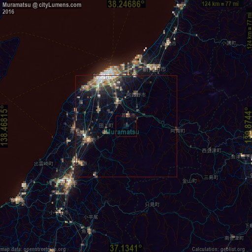
Analysis of Muramatsu night lights 2016
Square area 10x10 km:
 0%
0%90-99
0%80-89
0%70-79
0%60-69
0.34%50-59
0%40-49
0.34%30-39
1.02%20-29
0.85%10-19
1.19%0-9
96.26%Square area 50x50 km:
0.44%90-99
0.87%80-89
0.65%70-79
0.65%60-69
1.18%50-59
1.28%40-49
1.83%30-39
1.79%20-29
2.16%10-19
4.78%0-9
84.39%Clear (daylight) street map image can be seen on geolist.org.
Map coordinates:
38° 14' 48.7" North, 138° 28' 5.3" East
37° 41' 33.3" North, 139° 10' 16.6" East
37° 8' 2.8" North, 139° 52' 27.8" East
Some cities around Muramatsu sort by population:
• Sanjō
21.2 km =13.2 mi,  246°
246°
• Niitsu-honchō
12.7 km =7.9 mi,  340°
340°
• Tsubame
21.9 km =13.6 mi,  261°
261°
• Shirone
15.3 km =9.5 mi,  301°
301°
• Gosen
4.6 km =2.9 mi,  354°
354°
• Kameda-honchō
20.7 km =12.9 mi, 344°
• Kamo
12.4 km =7.7 mi, 255°
• Suibara
17.8 km =11.1 mi,  16°
16°
1856426 (p: 19,712)
Sources (retrieved 2019-11-25):
» Earth at Night: Flat Maps 2012, 2016