Mitake night lights from space
Night Light of Mitake (Gifu) from space (Japan) Src. Average luminocity for 10x10km area is 20.2564% and for 50x50km: 23.7964%.
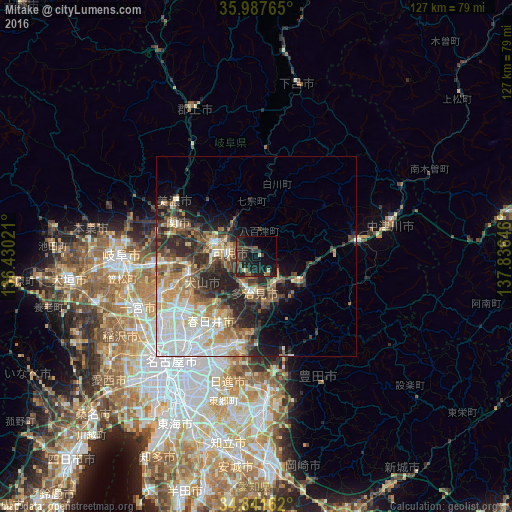
Analysis of Mitake night lights 2016
Square area 10x10 km:
100  0%
0%
90-99 1.47%
80-89 0.73%
70-79 0.73%
60-69 2.2%
50-59 3.66%
40-49 6.04%
30-39 8.97%
20-29 11.72%
10-19 31.32%
0-9 33.15%
0%90-99
1.47%80-89
0.73%70-79
0.73%60-69
2.2%50-59
3.66%40-49
6.04%30-39
8.97%20-29
11.72%10-19
31.32%0-9
33.15%Square area 50x50 km:
100 4.85%
90-99 4.6%
80-89 2.71%
70-79 3.13%
60-69 3.14%
50-59 3.42%
40-49 3.75%
30-39 3.39%
20-29 6.85%
10-19 6.66%
0-9 57.5%
4.85%90-99
4.6%80-89
2.71%70-79
3.13%60-69
3.14%50-59
3.42%40-49
3.75%30-39
3.39%20-29
6.85%10-19
6.66%0-9
57.5%Clear (daylight) street map image can be seen on geolist.org.
Map coordinates:
35° 59' 15.5" North, 136° 25' 48.8" East
35° 25' 0" North, 137° 7' 60" East
34° 50' 29.8" North, 137° 50' 11.3" East
Some cities around Mitake sort by population:
• Kasugai
23.8 km =14.8 mi,  217°
217°
• Seto
20.6 km =12.8 mi,  188°
188°
• Tajimi
11.1 km =6.9 mi,  180°
180°
• Inuyama
17.7 km =11 mi,  256°
256°
• Toki
8.7 km =5.4 mi,  148°
148°
• Minokamo
12.5 km =7.8 mi,  305°
305°
• Mizunami
11.9 km =7.4 mi,  117°
117°
• Mino
23.5 km =14.6 mi,  303°
303°
1856938 (p: 19,340)
Sources (retrieved 2019-11-25):
» Earth at Night: Flat Maps 2012, 2016